When selecting a European cycling tour with Sierra Sports & Tours it is generally a good idea to first consult our tour gradings. All of our cycling tours are graded on a scale of 1-5 Sierra cyclists. A grading of 1 is for ‘Beginners’ and 5 is for ‘Experts’. The system is generic so a level 2 in Spain will essentially be a level 2 in France and so on. Sometimes we need to grade a tour as 1-2 or 2-3 Sierra cyclists. The gradings are set based on the difficulty of the daily tour rides and our overall experience from cycling with clients of all levels. Below you can find a description of the levels, average ride distances & elevation gain, and recommended Sierra tours for each grading. We hope this blog post helps you and remember you can always Contact Us with any tour specific questions!
FOR ROAD BIKE TRIPS…
Cycling: Average Daily Rides: 30–50 km| Average Daily Elevation: 500m elevation gain| Average Riding Time: 2-3 Hours
My Palmares: I’m quite new to cycling but keen to get out on the bike and take it all in. I prefer to ride flatter terrain but I can still ride 2-3km climbs when necessary. If the going gets too tough I won’t mind hopping in the support van and there might be days on tour when I decide to take up some of the planned non-cycling activities.
Recommended Sierra tours: Girona Self-Guided & Go Private Tours
Cycling: Average Daily Rides: 50 – 70km | Average Daily Elevation: 500-1000m elevation gain | Average Riding Time: 3 – 4 Hours
My Palmares: I ride regularly and live a fairly active lifestyle. I’ve begun to start challenging myself on the bike and am up with all the jargon such as watts/kg, interval training, Strava, etc. Hills are becoming my friend! I want to come on tour and ride every day. I find I can back-up day after day when it comes to riding climbs that are 5-8km long.
Recommended Sierra tours: Girona Guided & Self-Guided, Giro/TDF/Vuelta & Go Private Tours
Cycling: Average Daily Rides: 70 – 90km | Average Daily Elevation: 1000-1500m elevation gain | Average Riding Time: 4 – 5 Hours
My Palmares: Cycling is a central part of my life. I do things such as ride to work or look for the local peloton to join for weekend rides. I really enjoy the physical challenge which cycling brings and have started signing-up to gran fondo events and long weekend cycling getaways. 10-15km long climbs don’t scare me! I am also in tune with the N+1 bike concept!
Recommended Sierra tours: Girona Guided & Self-Guided, Spring Classics/Giro/TDF/Vuelta, l’Eroica & Tuscany, Cazorla Gravel & Go Private Tours
Cycling: Average Daily Rides: 90 – 110km | Average Daily Elevation: 1500-2000m| Average Riding Time: 5-6 Hours
My Palmares: When my training is in full-swing it is easy to consistently ride 200-250km/week. You’ve probably seen me at one of those major gran fondo events where on any given day we tap out 200km and 3000m+ elevation gain. I love to push my limits! I look forward to reaching the summit of Category 1 and Hors Categorie climbs because I know they are my friend. You know what? I even dabble in the world of pickle juice and other cramp related remedies!
Recommended Sierra tours: Girona Guided, Spring Classics, l’Eroica & Tuscany, Cazorla Gravel, Pyrenees Coast 2 Coast, Epic French Alps, Epic Italian Alps & Go Private Tours
Cycling: Average Daily Rides: 120km + | Average Daily Elevation: 2000m + elevation gain | Average Riding Time: 6+ Hours
My Palmares: Whatever you throw at me I will give it a go! I have gone away and ridden trips with multiple back-to-back 200km day rides. I am always looking for my next cycling challenge and the big European events like the Raid Pyrenean 100hr challenge excite me rather than give me nightmares!
Recommended Sierra tours: Girona (Go Private adding ventures into the Pyrenees), Pyrenees Coast 2 Coast (ride all optional extra climbs), Epic French Alps, Epic Italian Alps, Epic French & Italian Alps back-to-back (20 days) & Go Private Tours
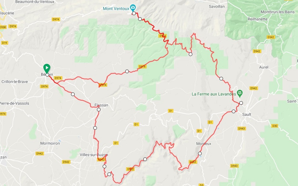
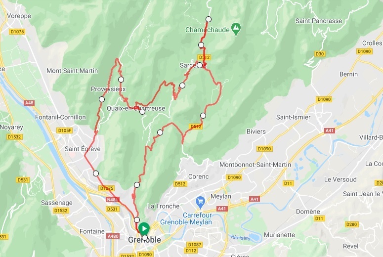
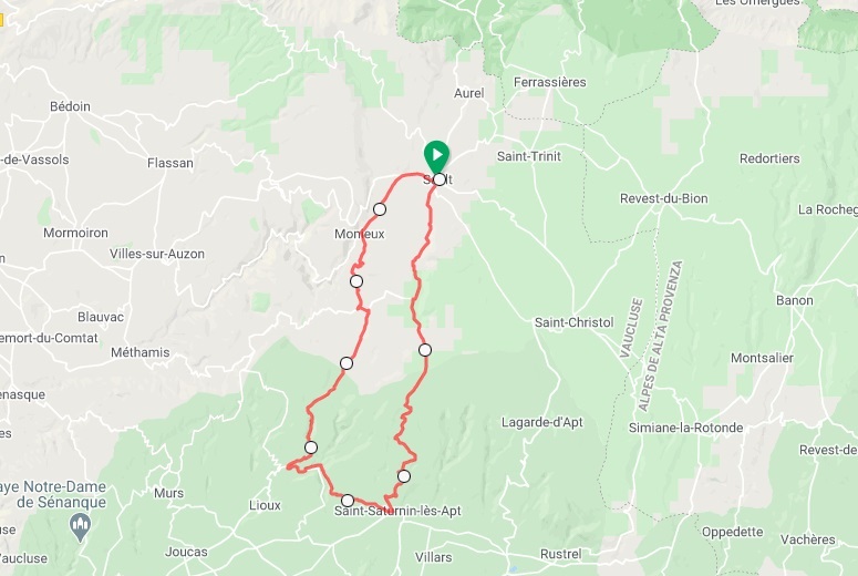
The Costa Brava is undoubtedly one of Europe’s key cycling destinations. Found in the north-eastern corner of Spain this region is geographically very compact which means many great rides are all in striking distance from a few key centres. Girona is the main hub and being quite central makes it a good starting point for most. It is also only a 1.5hr drive from beuatiful Barcelona so an international airport is relatively close-by. From Girona it is also possible to easily branch out into the neighbouring medieval villages and coastal towns.
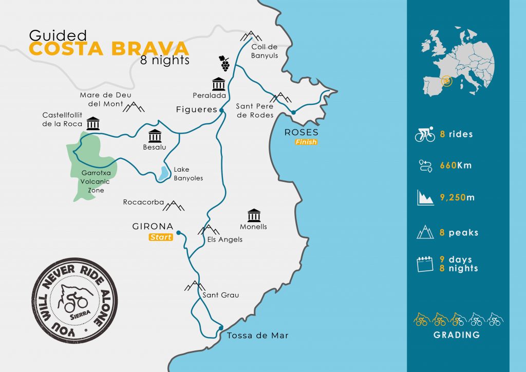
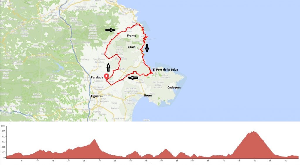
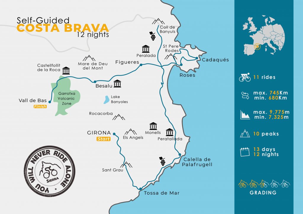
The layout of our 8 night guided Costa Brava cycling tour
Another major attraction is the weather. Why do you think approximately 100 professional cyclists decide to call the Girona region home? Road cycling is basically possible all year round though we prefer the April to June and September to November periods. There is nothing wrong with July/August but being the main summer holiday months in Europe it is often crowded and there is more traffic on the roads.
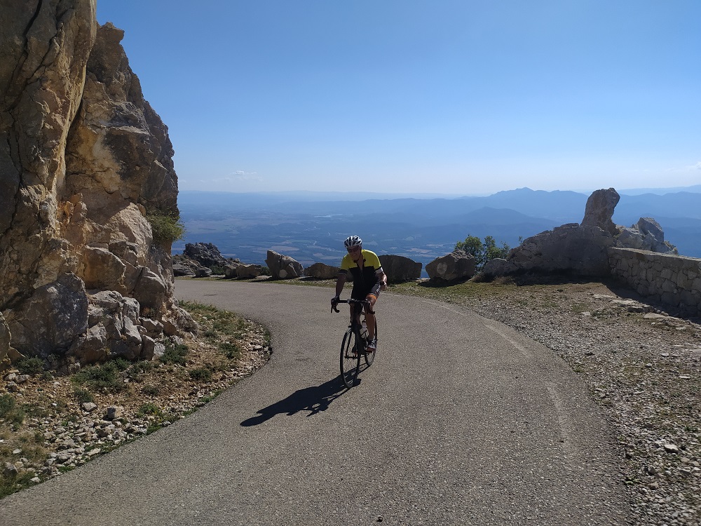
When it comes to straight out climbing potential Costa Brava is not the French Alps/Pyrenees or Italian Alps! However, for many that is also one of its main drawcards. The main road cycling peaks near Girona are typically less than 1000m altitude which usually means no snow-capped mountains. The region though still has very good climbing potential but it is fair to say that road cyclists who prefer shorter climbs and undulating roads are going to be in their element. There are many 5-8km long climbs scattered across the entire Costa Brava region (Els Angels, Santa Pellaia, Sant Grau, Sant Pere de Rodes, Coll de Banyuls & Col de Bracons to name a few). With this type of cycling terrain, the great year-round weather and the busy July/August summer period we know where we like to ride and train to kick start our European pre-season or to prolong our European summer cycling opportunities!
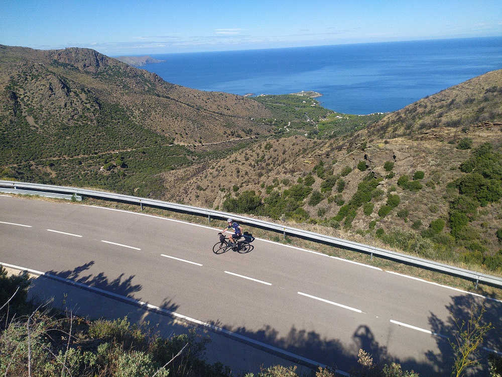
Coastal views down to the Mediterranean
Quick Geography Lesson
The main zones of the Costa Brava (especially when it comes to road cycling) can be divided into El Girones, La Baix Emporda, L’Alt Emporda, Pla de l’Estany and La Garrotxa. Each región has something special to offer when it comes to road cycling.
Geography 101 – Costa Brava
Girona, part of El Girones zone, is a city of approximately 100,000 inhabitants in northern Catalonia (Spain). Much of the old quarter of this medieval city has been preserved (founded by the Romans in the 1st Century BC) and is often referred to as the ‘City of the Four Rivers’. The historic centre is full of reminders from the Romans, Arabs and Jews. Nearby cycling climbs to get familiar with include Els Angels and Santa Pellaia in Les Gavarres mountain range.
Many would have also heard of Lake Banyoles which is located 30km north of Girona capital. It was used during the 1992 Barcelona Olympics and is a natural lake located in the Pla de l’Estany region. The lake is approximately 2100m by 750m with an average depth of 15m that in several points is as deep as almost 50m. It is located in a natural tectonic depression. Lake Banyoles and its many cafeterias and restaurants on the eastern shore are the perfect place to either re-charge your batteries before attacking the adjacent Rocacorba climb or for celebrating your achievement.
As the name suggests, Volcanica de la Garrotxa Natural Park, is an area of extinct volcanoes which is another road cycling paradise. Castellfollit de la Roca is one of the most picturesque villages in La Garrotxa. Its church and houses cling to the top of a spectacular basalt rock flow escarpment. From Castelfollit the Oix-Beget set of linking climbs is a good place to start on very quiet roads. The climb with most prestige is arguably Mare de Deu del Mont and we also like Coll de Bracons. From La Garrotxa it is also possible to head further north in search of the Spanish/French Pyrenees border (some big climbs are there but that’s a topic for a future post).
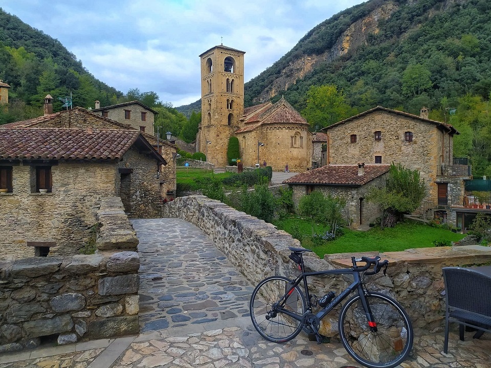
The hamlet of Beget – a quiet backroad cycling experience
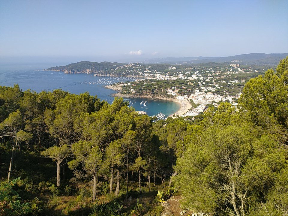
La Baix Emporda is directly to the south and east of Girona and includes many coastal ‘touristy’ townships. At times there can be more traffic and mass tourism but don’t let that put you off. Away from the busy months or even an early morning escape can still see you screaming along the Mediterranian coastline with a smile from ear to ear. The Sant Grau climb linking Girona to the coast is our pick and from Tossa de Mar to Sant Feliu this in general is a wonderful stretch of road!
L’Alt Emporda region is the last described here but definitely not the least. This region takes in coastal towns, interior mountains and incredible coves and capes that must be discovered by bike. The Gulf of Roses we think is a good starting point to discover L’Alt Emporda and the area between Peralada and Figueres is also very good. There are also many great wineries putting L’Alt Emporda on the map! When it comes to cycling up to the Sant Pere de Rodes Monastery you have two possible approaches which offer totally different perspectives. Be sure to check them both out. Coll de Banyuls is also a quiet road up to the Spanish/French border and perfect for an ‘easier’ climbing day.
Our 3 Favourite Cycling Climbs!
When you cycle Costa Brava you are going to hear the names of literally dozens of ‘cols’. It is not always easy to pick favourites but we can’t go past Rocacorba, Mare de Deu del Mont and Sant Pere de Rodes for the challenges the three present.
Mare de Deu del Mont (Alta Garrotxa región)
For most of our Costa Brava cycling tours the most challenging day on the bike is the climb to Mare de Deu del Mont. The climb is full of surprises and changing landscapes at every corner. At 1085m altitude the peak is the highest point in the eastern sector of the mountainous territory named Alta Garrotxa. The summit offers 360° degree views from what is our favourite viewing platform on the Costa Brava. The energy expended we believe is well and truly worth it. From Cabanelles it is an 18km climb with a 5.2% average gradient up to this Catalan sanctuary. It is an enjoyable climb on roads in the picturesque Alta Garrotxa mountains. The lower part is mostly in trees, but the scenery opens up towards the top, with some fine views. The first half of the climb is relatively gentle but the second half has its challenges with 13-14% short ramps to contend with. The road also narrows in the second half so take care and be attentive to traffic. At the top you have ‘Restaurante Bar Hostatgeria’ but take note that it is usually closed on Tuesday’s and Wednesday’s (even in peak season).
The views from Mare de Deu del Mont – can you spot Rocacorba in the background?
Mare de Deu del Mont can also be climbed from the small hamlet Beuda. Just quietly, this western approach is a great challenge. The first part of the climb from Beuda is a section of road which is 5.5km long and for the most part ranges between 7.5-9% grade. The road is narrow but reasonably well asphalted. Climbing is not the main issue though. If you decide to descend it then always apply safety first. It is a road that is hardly transited so when a car does pass it can be a surprise. So, on the narrow corners be vigilant but the main message is that if you take care and keep control of your speed then you can safely descend it. With 6.5km remaining to the Mare de Deu del Mont summit this road from Beuda connects with the main eastern approach (described above) from Cabanelles. The western approach in our opinion is an excellent option because it means that from Besalu and Beuda you can also climb Mare de deu del Mont without accessing the busy N260 road which links Besalu and Figueras.
Rocacorba (Pla de l’Estany región)
Rocacorba has become famous in recent years with professional riders using the climb for their hill interval sets. While the 13.5km is characterised by a 6% average grade the statistics hide some vicious ramps. The steeper gradients for example kick-in during the second part of the climb. There are 3 difficult km with no respite and the grades constantly sit between 9-11%. Take on this beast and just like the pro’s you too can rate your form. Pro’s are searching for sub-30 minutes, trained recreational riders sub-60 minutes and local master’s riders often set their target time as their age plus 10 minutes. How fast can you go? Whatever the case, at the top be sure to congratulate yourself on what is a wonderful achievement.
Happy campers at the top of Rocacorba!
For difficulty on the Costa Brava, Rocacorba and Mare de Deu del Mont are in direct competition. Please note though that the overall experience is completely different in our opinion. Mare de Deu del Mont has the 360 degree views, sizeable car park and bar at the top while Rocacorba only has a lone telecommunication tower and small viewing platform overlooking Lake Banyoles. Rocarcorba though is only a 30km warm-up ride to the base from Girona which we have to say is a real advantage. There is time to put in a solid effort and still get back to Girona for lunch! If you are late to start though don’t worry as you can descend directly to Lake Banyoles for your lunch stop. In the upper section of the climb a Rocacorba neighbour (during the 2022 season) set up an ‘honesty-system fridge’ at their property so that also might help anyone on the brink of bonking!
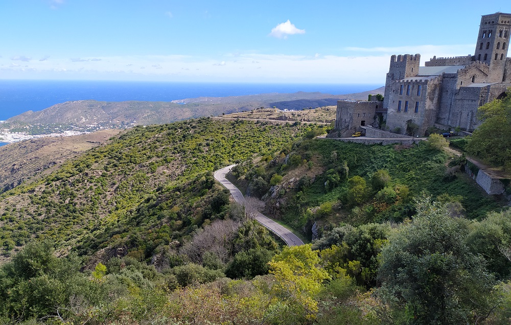
Sant Pere de Rodes (L’Alt Emporda region)
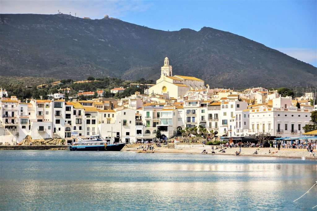
The climb though which the Sierra guides are always lining up for is Sant Pere de Rodes. This corner of the world is close to Cadaques/Cabo de Creus which is the most eastern point of the Iberian Peninsula and what seems to be only a stone’s throw away from the French border. On tour we often save this climb for last because the arrival at the picturesque Benedictine Monastery near the summit with its curving roads and spectacular coastal views all combine to create a memorable experience. The most difficult of the two possible ascents starts from the lovely beachside town of El Port de la Selva. Here the ‘Sant Pere’ climb begins from sea level and the views of the Mediterranean follow you all the way to the very top!
Where monasteries, cols and the coast combine – Sant Pere de Rodes
We think ‘Sant Pere’ is the most scenic climb in the entire Costa Brava region and that is saying something considering the natural beauty of Costa Brava! The 7.4km of winding roads from practically Km 0 offer majestic views down to the Mediterranean Sea. The 6.5% average grade seems manageable but the first 6km never drop below 7-9% average grade with many shorter pinches to also contend with.
The other approach to Sant Pere de Rodes starts from the inland town of Vilajuiga. This climb doesn’t get nearly as much attention as that previously mentioned (i.e. Port de la Selva). But if you have time we really recommend you climb both sides up to the Monastery. Either way you won’t be disappointed! The flowing descent from the summit down to Vilajuiga is also something to savour!
A Few Trade Secrets
The Costa Brava is home to many secret detours or ‘rincones’ (remote areas) which we believe really enhance the road cycling experience. We could write a small book, but here are a few you should keep in mind!
The French Connection
All routes designed on the Costa Brava are noteworthy but there is one that we particularly like and it affectionately goes by the name ‘The French Connection’ amongst our team. The riding begins and finishes on L’Alt Emporda but crosses into France for a good stretch of low-lying Pyrenees and coastal roads. It is a quality ride and also comes with historical significance. The crossing from Spain to France heads up and over the relatively ‘soft’ Coll de Banyuls. It is a 9.5km climb on quiet roads which only rises up to approximately 340m altitude. While it is a gentle climb for the most part there are four or five short pinch points with 10% ramps. If you are doing an up and back ride only then take note of the cattle grids on the way up and remember to slow down for them on the way down.
During late 2022 the border was closed for traffic (massive concrete road blocks in place and which don’t appear to be going anywhere fast) but bikes can easily pass. The views over to France which overlook Banyuls-sur-Mer are first-class. The first couple of kilometres on the French side of Coll de Banyuls are very steep, tight corners and narrow so safety first please! Also, keep the steepness in mind if you have to ride back over to Spain again. The final 2km include ramps that nearly hit 20% grades resulting in a tough test. The below ride map though continues through to France so you can skip these insane grades and simply focus on getting down safely.
The French Connection Loop Ride: 95km & 1650m elevation gain
Time for some history – Between the end of January and the beginning of February 1939, it is estimated that some 350,000 Spaniards fled to France through the Pertús, Coll de Banyuls and other points of the Alt Empordà region of Costa Brava. On 26 January 1939, the rebel troops of General Franco occupied Barcelona. The Spanish Civil War had practically come to an end and the victory of the Rebel Army was imminent. But for all those people who had fought alongside the democratic legality embodied by the Republic, a period marked by repression and silence began. To avoid this situation, thousands of citizens, both military and civilian (men, women and children), had to flee and leave their work, their homes and families. As you reach the ‘Banyuls’ summit it is worth reflecting on the history but also marvelling at this iconic ‘rincon’ on the Spanish/French border!
Back to the route – once down in Banyuls-sur-Mer (France) there is about 15km of cycling which hugs the coastline all the way back to the Spanish border (Coll des Belitres). Twenty kilometres later you are in El Port de la Selva and the base of the more difficult ‘Sant Pere to Rodes’ ascent (as previously described). Finishing this loop ride on what is a gem of a climb and then riding down to the Gulf of Roses beaches or through to the Peralada/Figueras townships rounds out what we think is an excellent day on the bike.
Worthy of a Special Mention – Coll de Bracons
Hidden away in the quiet Vall de Bas (Osana region of La Garrotxa) is this special climb which doubles as a great escape into what is a picturesque valley. The valley is surrounded by mountains that peak at 1500m elevation and the area is very lush and a paradise for agriculture and livestock raising. It would be fair to say that most travellers don’t venture into this corner of Costa Brava (despite it only being a 50km drive north-west from Girona). However, the locals know it only too well thanks to the annual ‘Terra de Remences’ gran fondo ride. This event will be held on 14 May 2023 and there is a 100km loop (1280m elevation gain) and a 175km loop (2600m elevation gain) to choose from.
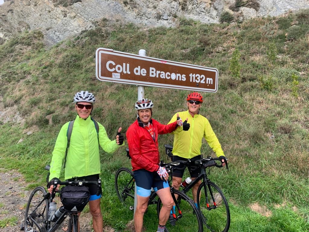
Coll de Bracons is one of the major climbs on-route and from Can Trona its 8.4km at 7.8% average grade will get you sweating. The first half of the climb ranges between 4-7% so you can guess what the second part looks like. Basically, there is not too much asphalt over the final few kilometres below double digits!
Job well-done on the Coll de Bracons summit in La Garrotxa region
Gateway to the Pyrenees
The Costa Brava in many ways can also be considered as a gateway to the Pyrenees. We are not going to go into detail during this blog but at least we have made the reference. If you have a vehicle to move around the Costa Brava then there is nothing stopping you from a trip to ‘Vallter 2000’ and ‘Coll de la Creueta’. Two totally different climbs with equally varying ride statistics but excellent cycling adventures respectively.
How to get there?
Most Costa Brava cycling expeditions kick off in Girona. There are many transport options to the city centre and it is the perfect place to get over any jet lag and fine tune the bikes. If you happen to be joining a Sierra tour then our guides and 9-seater vans will always be close by to help. If you have selected a guided Sierra tour then the Barcelona-Girona and vice versa transfer price (for you and your bike bag) is already included.
All other cyclists visiting Costa Brava will need to assess their transfer options and this is usually best done based on whether you will be arriving with or without a bike box. Bus and train options, whilst possible, are often more difficult and stressful when travelling with a bike box. If you are coming into Girona train station or Girona airport with your bike then a taxi will be quick, cheap and easy. However, you and your bike box via taxi from Barcelona Airport to central Girona will most likely come with a 200 Euro price tag.
Many cyclists visiting the Costa Brava often spend a few initial days in beautiful Barcelona. If you are travelling without a bike box then from the Catalan capital we can recommend public transport services. Buses leave from ‘Estacio del Nord’ and the Sagales bus company has one-way tickets from approximately 20€. A bike box is treated as over-size luggage and an additional standard ticket price is also required. Whether your bike box can be stored away will also be subject to availability in the underneath luggage compartment so this bus option comes with its own challenges for travellers with bike boxes.
If you prefer train travel, then from Barcelona-El Prat Airport you will first need to find the RENFE station at terminal T2 (there is a free airport bus between T1 and T2). From T2 you can catch the metro line to the central Barcelona-Sants train station (about 5€ for the 20-minute one-way trip). A taxi from Barcelona-El Prat Airport to Barcelona-Sants train station is more likely to be around 40-50 Euro.
Now that you have arrived to Barcelona-Sants train station you can board the high-speed AVE train to Girona city centre. One-way tickets start from around 20€ and the trip usually takes about 40 minutes. Be careful with the high-speed AVE train though as there are strict luggage requirements. RENFE allows one large suitcase only so if you also arrive with your bike box you will encounter a problem.
If you have luggage and a bike box then a good alternative is to make your way to nearby ‘Passeig de Gracia’ train station in the Barcelona city centre. Take a regional train from here which has no luggage restrictions, leaves every hour, costs less than 10€ and typically takes between 75-90 minutes to central Girona.
Where to Stay?
We have already mentioned that Girona being a central hub is a great place to stay for your Costa Brava holiday. There are many hotels and apartments to choose from and the old town with its many cycling focused coffee shops, its plazas, bars and restaurants makes it a very comfortable option.
If you are longing for the sea though, then why not consider a stay in Calella and/or around the Gulf of Roses. We think you will also be impressed by El Port de la Selva sitting at the base of the Sant Pere de Rodes monastery.
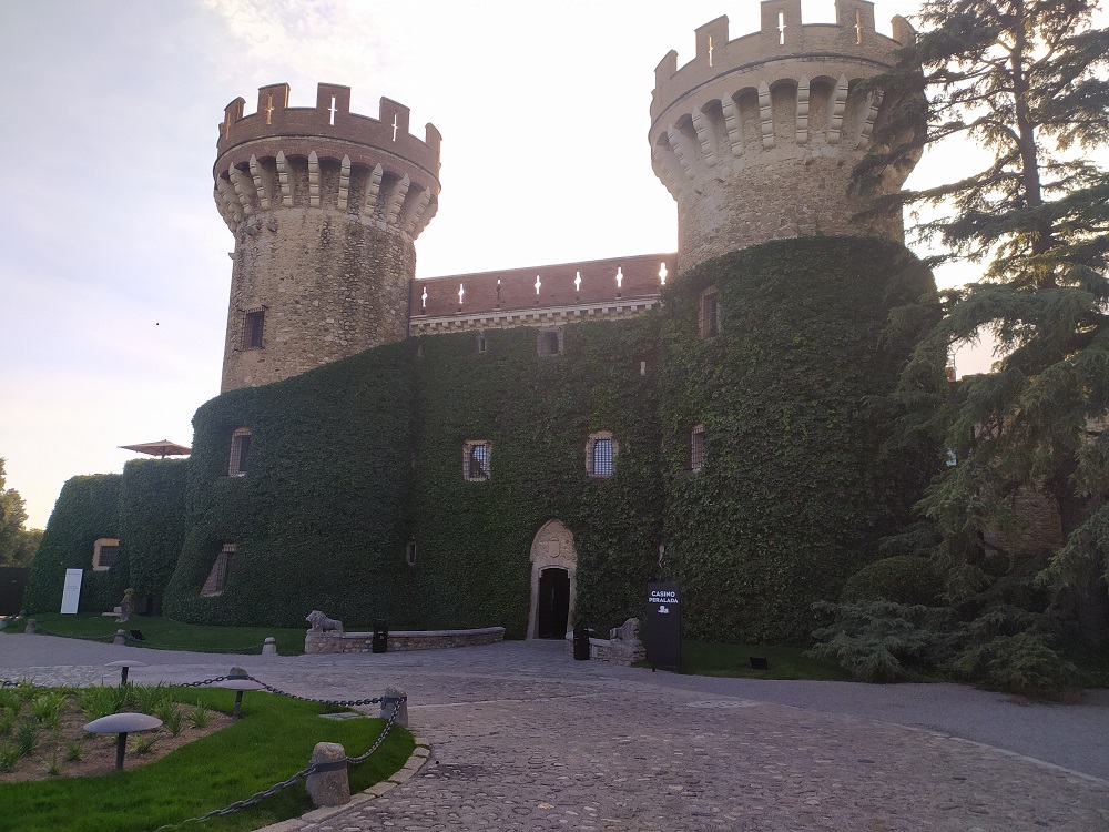
Of the medieval villages we like Peralada as a potential cycling base for a few good days of exploring. Peralada is located in the “Alt Empordà” and its origins go back to an Iberian settlement approximately from the year 500 B.C. Today, it is predominantly an agricultural and wine-growing area, producing a great variety of wines under the Empordà D.O. It has also a small population with less than 2000 inhabitants.
Castillo de Peralada
Costa Brava – It’s not all about the bikes
Well actually it is! Who were we trying to kid? But jokes aside, it is possible to design any ride on the Costa Brava so it passes a medieval village, a Dali inspired attraction, a top-shelf winery or more recently a micro-brewery or ‘sidreria’ (cider anyone?).
As you move away from Girona there are many jewels across the entire Costa Brava region to enjoy. The famous and local surrealist artist Salvador Dali has well and truly left his mark (check out Pubol, Figueras and Cadaques), striking medieval villages and monuments are scattered over the region and the Catalan cuisine is also incredibly appetising!
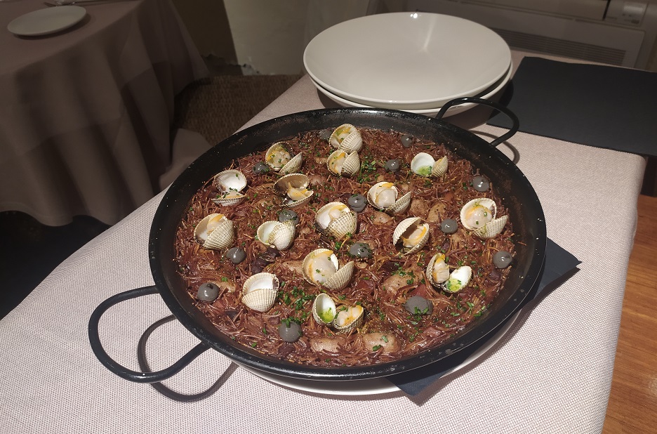
Fideua de marisco – Seafood noodles anyone?
Medieval Villages
As mentioned, the Costa Brava contains enchanting towns like Monells (El Girones , Peratallada and Pals (La Baix Emporda), Peralada (L’Alt Emporda) and Besalu (La Garrotxa).
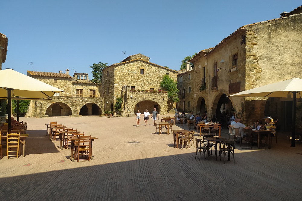
Monells is a small medieval town located in the Baix Emporda region and its name comes from Villa Mulinnensis, as there were many mills in the area. The first written records date back to around the 10th Century and sections of the old medieval wall are preserved. We recommend that you hop off your bikes for a while and walk the cobblestone streets of the town observing its architecture, stone arches and its squares mainly in Gothic style. The main square ‘Plaza Jaume I’ is enclosed by stone houses and full of terraces where you can have a drink. ‘El Roura Blanch’ is a real favourite with the locals.
Monells is like stepping back in time (10th Century origins)
Peratallada is a magnificent architectural site presided over by an elegant castle and surrounded by defensive walls and a moat, which has managed to perfectly preserve the medieval atmosphere of its origins. We like to cycle in from its main entrance found to the east of the town and out by the northern archway (Portal de la Verge) which joins the road towards Canapost.
Besalu is another classic town in La Garrotxa with a long history. The first signs of settlement date back to Iberian settlements 1000 years B.C. It later became an important urban centre for the Roman Empire, however, its medieval past is what makes it worth visiting today. It is difficult to find a town with so much history per square metre. It is one of the best-preserved medieval centres in all of Catalonia. The Romanesque bridge is perhaps the most important element of the village and the best access to visit the old part of the town. It is a 105m long bridge with an impressive tower and which has seen a battle or two!
Salvador Dali
Figueres is fondly known as the home of Salvador Dalí. This town in L’Alt Emporda, between Besalu and Roses, has deep Catalan roots. Visitors have the chance to visit the Dalí Theatre-Museum which has become one of the main cultural places in the city. Designed by the artist himself, it holds many of his most important works, and which allows you to take a trip through the career of the man considered a master of Surrealism. The site was extended with the Torre Galatea, where the artistic genius died. Let us know what you think about all of the giant eggs on the roof!!!
The story goes that Dali had also always promised his wife Gala that he would buy her a castle. In 1969 the dream became reality when he bought her Castillo de Pubol (25km north-east of Girona). It was in bad condition so the artist you could say ‘got to work’. A visit to this Dali renovated castle is for many an even better experience than the above-mentioned Figueres museum.
At the head of Cadaqués bay is its historic quarter, with a Mediterranean air and deep seaside flavour. The source of inspiration for internationally famous painters and artists for decades, today this centre enjoys an intense cultural life, as witnessed by its many museums and art galleries, among which the Salvador Dalí House-Museum which is outstanding.
Cadaques – Dali’s inspiration
Wineries
From La Baix Emporda to the south to L’Alt Emporda in the north there are some wonderful wineries that are really going places. Depending on where your cycling adventure takes you be sure to try and organise a visit to at least one of the below wineries:
Finca Bell-Lloc: Located near the town of Palamos (La Baix Emporda) this estate (‘finca’ in Spanish) is many things all rolled into one. The comfortable accommodation settled amongst the beauty of the forested estate, the ruins of the Vila Romà Castle on-site, the underground wine cellar for tastings and the acclaimed restaurant combine to create a wonderful experience. The final kilometre entry to the ‘finca’ follows a maze of compacted dirt roads accessible by road bike. As you park your bike below the outdoor terrace you know that you are in for something special!
La Vinyeta: Whenever we are cycling near medieval Peralada we try to combine a visit to this modern wine cellar. La Vinyeta is a small vineyard and olive farm situated at the heart of the L’Alt Empordà. The origin of this project dates back to 2002, when two old Carignan and Grenache vineyards – aged between 50 and 75 years – were purchased. In 2009, La Vinyeta became one of the first wineries to adopt an environmentally friendly cultivation system. We hope you can enjoy a detour to ‘La Vinyeta’!
Why ride Costa Brava with Sierra?
The advantage of joining a Girona & Costa Brava cycling tour is the flexibility we provide regarding available options. Being based in Spain we offer fully guided tours through to more economical partially guided and self-guided adventures. You can jump on a tour with scheduled dates as listed on the web or get a private group together and set your own dates. Below you will find some background information in relation to how each tour type works. The choice is then up to you!
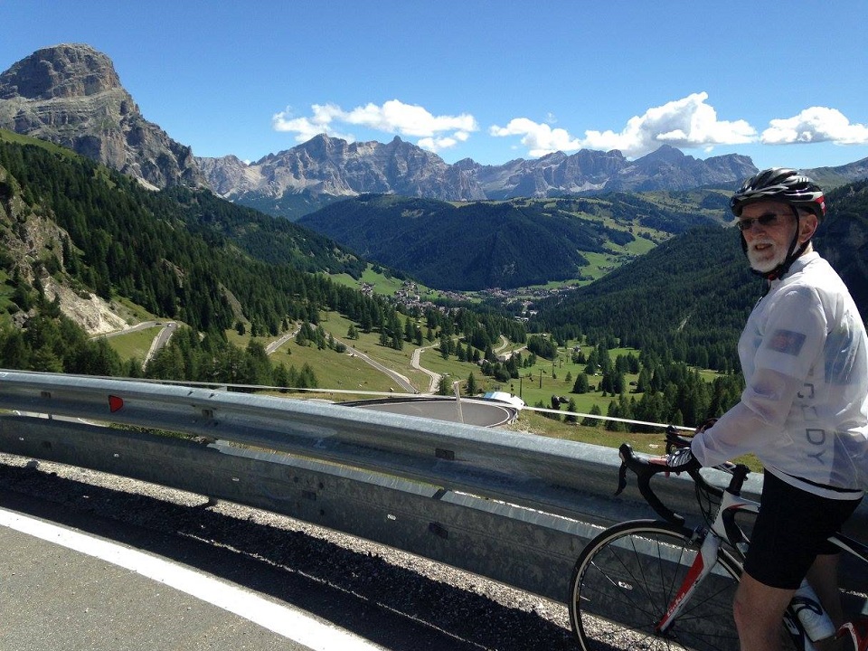
Fully Guided Cycling Tours: These are group travel experiences where individual travellers sign up to a web-listed package with a set itinerary and set dates (11-19 May and 17-25 October during 2023). Clients from all over the world sign up via the online booking form and we organise the rest. The formed group is led by the Sierra team from the start to finish of the tour. There is a lead cycling guide out on the road with the group at all times and a following support van with experienced driver/mechanic. The support van carries a full-set of bike tools and parts, spare wheels, complimentary food and drink and also guest day packs with additional clothing, towels, etc. The vans also come with roof racks for transporting up to 10 bikes so if you are having an off-day the van ‘is your friend’ as Sierra tour leader Jorge likes to say.
Paul leading the troops up Mare de Deu del Mont
Self-Guided Cycling Tours: Sierra has rolled out many self-guided tours for guests who are more experienced travellers who love making their own adventure, typically enjoy travelling in small groups with friends or family (minimum 2 clients) and/or are looking for a more budget friendly tour option. In such instances, the Sierra office prepares the tour itinerary, books the accommodation and nine times out of ten also organises the hire bikes (which could be hybrid, road bike or both of these forms of e-bike. During 2023, Sierra has a variety of 6 night, 9 night and 12 night Girona & Costa Brava Self-Guided tour itineraries to choose from.
The Sierra self-guided formula for success includes a local guide that meets you at the initial hotel in central Girona. At this time there is the bike hand-over (which includes fitting), small toolkit, floor pump, chains/padlocks and e-bike charges (if necessary). A detailed briefing going through the client booklet and what you all have in store over the coming days is also conducted. There is no guide with the group during the daily rides but what Sierra does offer being local is a 24hr emergency support phone number in the event their clients strike any issues.
Self-Guided cycling tour options: 6, 9 & 12 night packages available
Go Private tours: The guided private tour involves rounding up a group of friends and stating the number of tour days and the specific tour dates you require. You will be assigned a Sierra team with lead cycling guide and support driver/mechanic. However, perhaps you prefer the concept of ‘Partially Guided’. It is a private group experience where you follow a set itinerary prepared by Sierra for a specific duration and your selected preferred dates. What is different though is that there is no lead cycling guide on tour. The Sierra guide in this case is the support driver/mechanic. A van will follow you providing the daily ride assistance you are looking for. Partially guided is perfect for those setting off on long challenging daily rides and who know too well the importance of having extra gear on-hand for the mountains and the need to have plenty of food and drink. At the same time, these types of riders are accustomed to riding in their own group, are comfortable using a Garmin and following pre-designed GPX files.
Costa Brava: the Final Word!
One of the great features about the Costa Brava is that you can make the cycling as easy or as difficult as you like. If easy rides are preferred then there are many bike trails available. They might not all be suitable though for road cycling (gravel bikes? – well that is what we have begun planning for the near future – stay tuned)! If you have some training in the legs then ‘medium-level’ rides out of Girona will see you tick-off fantastic 5-8km climbs such as Els Angels, Santa Pellaia and Sant Grau. For the more advanced or adventurous riders in the peloton you will be wanting to take on the more difficult challenges around the region including Mare de Deu del Mont, Rocacorba, Sant Pere de Rodes and Coll de Bracons to name a few!
Remember, it is also a long cycling season on the Costa Brava so choose your dates wisely. You will know if you prefer busy or quiet traffic conditions; cooler, warmer or hotter weather conditions and cheaper or more expensive accommodation prices (July/August – peak season prices for example).
In summing up, cycling through the Costa Brava guarantees you a variety of picture-perfect views. These will come from hilltop monasteries, spectacular lakes, small coastal coves, ancient volcanic landscapes (over 10000 years since the last eruption – phew!), breathtaking lookout points, beaches and serpentine roads along the Mediterranean coast. The combination of nature, history, architecture, gastronomy and well-maintained roads provide the perfect setting for creating what will be an unforgettable cycling experience. We hope this Costa Brava cycling guide serves to inspire your next Spanish cycling holiday!
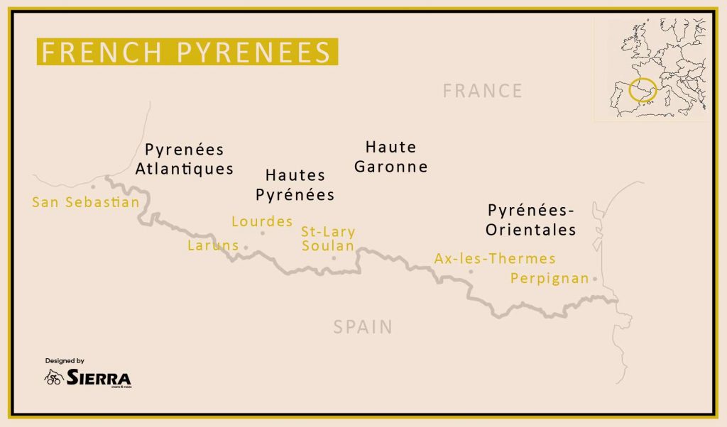
The Pyrenees are a major mountain range that form a natural border between Spain and France and which also encompass Andorra a small territory with hardly a flat metre within its border! The Pyrenees mountain range spans approximately 450km between the Mediterranean and the Atlantic Ocean.
In this blog we share our road cycling knowledge on the famous ‘cols’ to be ridden, some of our favourite cycling routes including profiles and options of where to start and base your French Pyrenees cycling challenge.
What we believe makes the French Pyrenees great are the small towns, the agricultural lifestyle, the remote ‘feel’ and the mixture between truly epic Tour de France cycling cols and straight out hidden gems that Le Tour cannot access.
After looking through your geography books you will have uncovered a number of Pyrenees sub-regions and legendary road cycling peaks. The main objective of this ‘Cycling in the French Pyrenees’ blog is to focus on the major cycling challenges in the Pyrenees-Atlantiques, Haute-Pyrenees and Haute-Garonne departments. Be sure to read through to the end as we conclude by presenting a detailed list of fantastic Pyrenees cols.
Classic Cols in the French Pyrenees
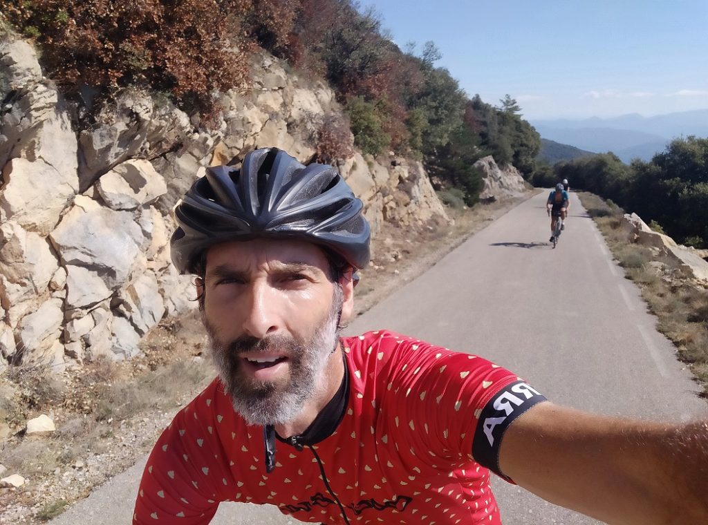
Here we present our favourite ten cycling cols from the French Pyrenees. As it goes all of these happen to be from the Pyrenees-Atlantiques and Hautes-Pyrenees departments. It was a difficult exercise but these are truly special climbs from our experience organising road bike cycling tours in Europe. A selection of other top-class climbs from these regions plus the Haute-Garonne are also described in later sections of this blog. Now to sit back and dream of cycling these French Pyrenees classic cols. This is no order of preference. Just a simple ‘west to east’ crossing of the Pyrenees mountain range.
Port de Larrau (Pyrenees-Atlantiques)
Probably a climb that most recreational cyclists have not heard too much about (and will not be high on many bucket-lists) but a climb we must feature and which we have found even more difficult than other big named climbs, such as, Tourmalet or Aubisque. Port de Larrau is located in the Pyrenees-Atlantiques region and has only featured twice in Tour de France history (1996 and 2007).
In 1996 it was rolled out for the first time as a special tribute to five time Tour de France champion Miguel Indurain. You see at the top of ‘Larrau’ you intersect the Spanish border. Big Mig is from Pamplona (Spain) and his TDF reign spanned from 1991-1995. The Stage 17 route from Argeles-Gazost to Pamplona was to be the final major climb of the 1996 tour and create a celebration for Miguel through his hometown of Vilava.
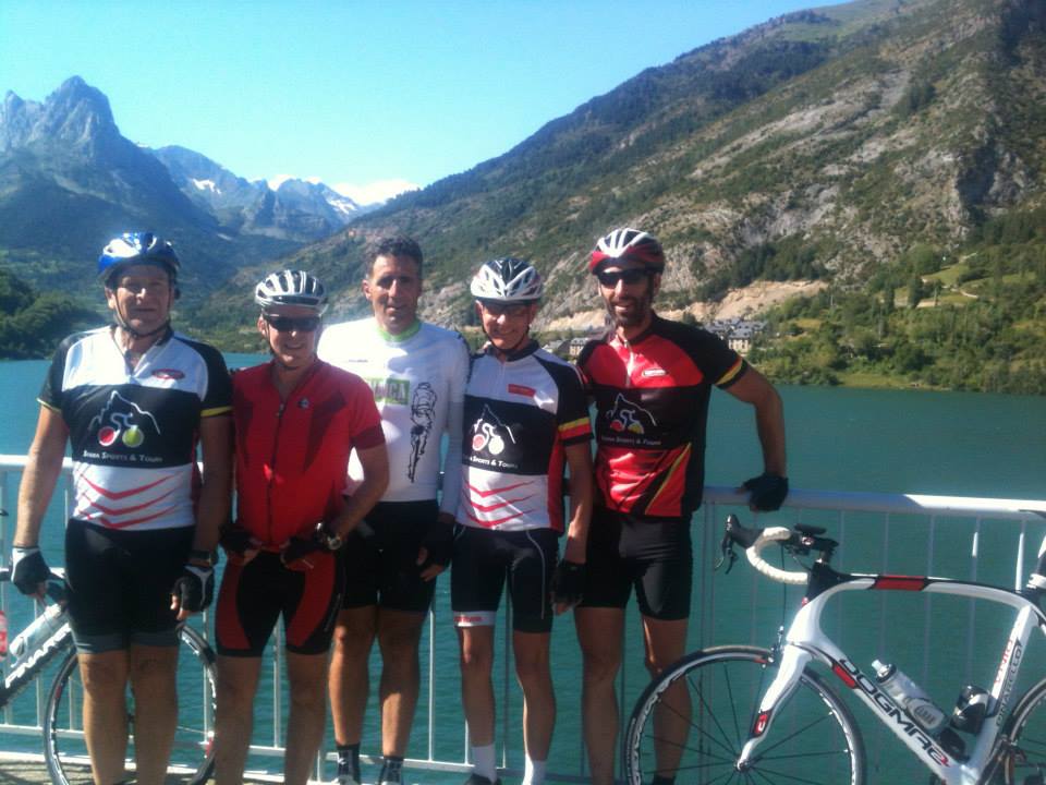
As history goes though, everything started to go very wrong for Big Mig the day earlier on Hautacam. Things then went from bad to worse on ‘Larrau’ as he was unable to keep up with the Rijs/Ulrich Telekom train and there was no party in his hometown. Finally, he slipped to 11th overall and his TDF rule was ended. It was a fabulous run though from 1991-95 and you can click here to read about our Sierra clients riding with Miguel Indurain in the Pyrenees back in 2012.
The Sierra guests cycling with Miguel Indurain up to the Formigal Ski Station (Pyrenees)
Returning to the ride statistics and Port de Larrau from the French side measures a total of 14.8km with an 8.1% average grade. Riding this approach though means you first pass Col de Erroimendi after 10.3km (9.4% average grade with at least eleven pinches with ramps between 12-16%. The following 3km average an easy 2% before a final 2km test (10% average) up to Larrau and the French/Spanish border. A great summit, remote, practically free of traffic and which opens up the Spanish Pyrenees for those who are looking for a different type of Pyrenees cycling experience.
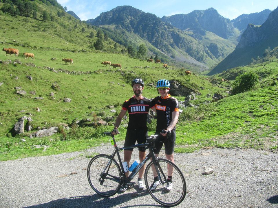
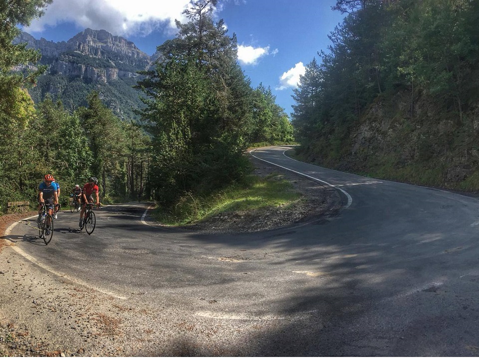
Green summits are typical for the big climbs in the Pyrenees-Atlantiques
Col de la Pierre San Martin (Pyrenees-Atlantiques)
A big challenge awaits for those who are game with this 25km climb at 5.5% average grade. Rising out of the sleepy town of Arette you know there is something rather special awaiting. As you get yourself prepared there is a wall dedicated to about 15 local professional cyclists from various generations.
This climb follows the main N302 all the way up to the summit and was the route selected when Chris Froome won the Stage 10 summit finish during the 2015 Tour de France atop Col de la Pierre San Martin! The only other Tour de France summit finish was in 2007. Another relatively unknown climb just got put on the map on the French/Spanish border.
Col de la Pierre San Martin has recently been put on the map thanks to the Tour de France
But what makes this area a small goldmine for road cycling purists is the 7 ascents from the French side which all in one way or another make their way towards this French/Spanish border summit. Drawing a 25km radius around Arette and you can find all of the 7 approaches that eventually lead one up to Col de la Pierre San Martin (1766m elevation). Town names, such as, Osse-en-Aspe, Issor, Lourdis-Ichere, Licq-Atherey, Sainte-Engrace and Lanne-en-Baretours should be stored away for when planning your cycling holiday in this region.
For a serious challenge we like the climb from Lanne-en-Baretours. The initial 12km finishes atop Col de Issarbe (1455m elevation, 8.5% average grade) and include no less than 10 ramps between 12-18%. Some energy has already been expended and you are only half way! Continuing on and Col de Soudet is greeted at the intersection of the previously mentioned main N302 road. Now it is only 3.7km to the Col de la Pierre San Martin summit on the French/Spanish border. It is interesting to note that we have found reference to Col de Soudet during the 1987, 1991, 1995 and 2006 editions of the Tour de France.
Descending Col de la Pierre San Martin from France and down into Spain
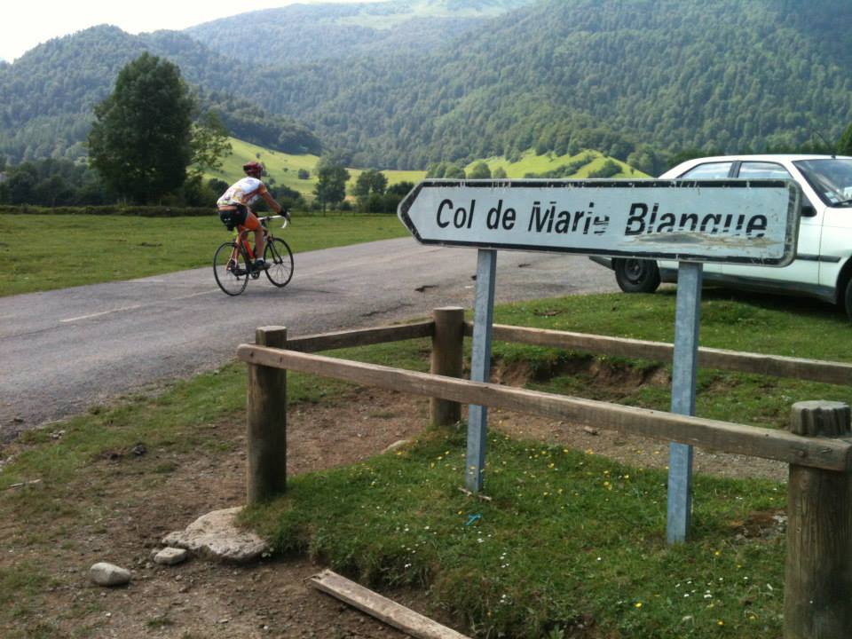
Col de Marie Blanque (Pyrenees-Atlantiques)
Next stop is Col de Marie Blanque with 30+ TDF crossings! The climb from Escot (western approach) does not need too much of an introduction. It is short but also very sweet as was perfectly demonstrated during Stage 9 of the 2020 Tour de France. This was the first moment that we knew Tadej Pogacar was a real contender for the yellow jersey.
TIme to celebrate on this short but steep Tour de France classic
The Marie Blanque climb from Escot measures 9.4km and rises at an average grade of 7.5%. The average grade though does not depict the nature of the climb at all. If you can remember plotting exponential functions at secondary school then you will get what I mean. The initial km’s range between 2-4%, the middle sections between 5-6% before the final onslaught which includes 3km at 11.5% grade!
It is also a difficult climb to pace because all the while you are covered in thick forest and you never see more than a few hundred metres of road in front of you. Where is the top you keep on telling yourself! With the relatively straight forward start it is easy to get into a false sense of security before blowing up on the finish. I think we all saw this first hand when Pogacar and Roglic almost overlapped wheels on the Marie Blanque summit during September 2020. A lack of concentration from the effort exerted nearly left them both on the tarmac.
If all of that sounds a little too strenuous then the climb from the east is 11.5km long and it’s friendlier 5% average grade hides no monsters.
Hitting up Col de Marie Blanque from its easier eastern approach
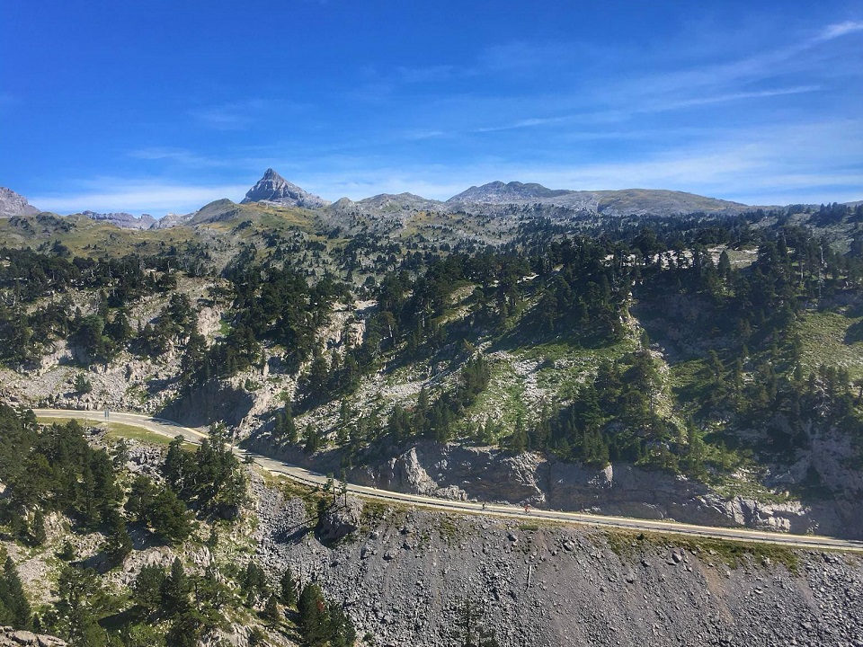
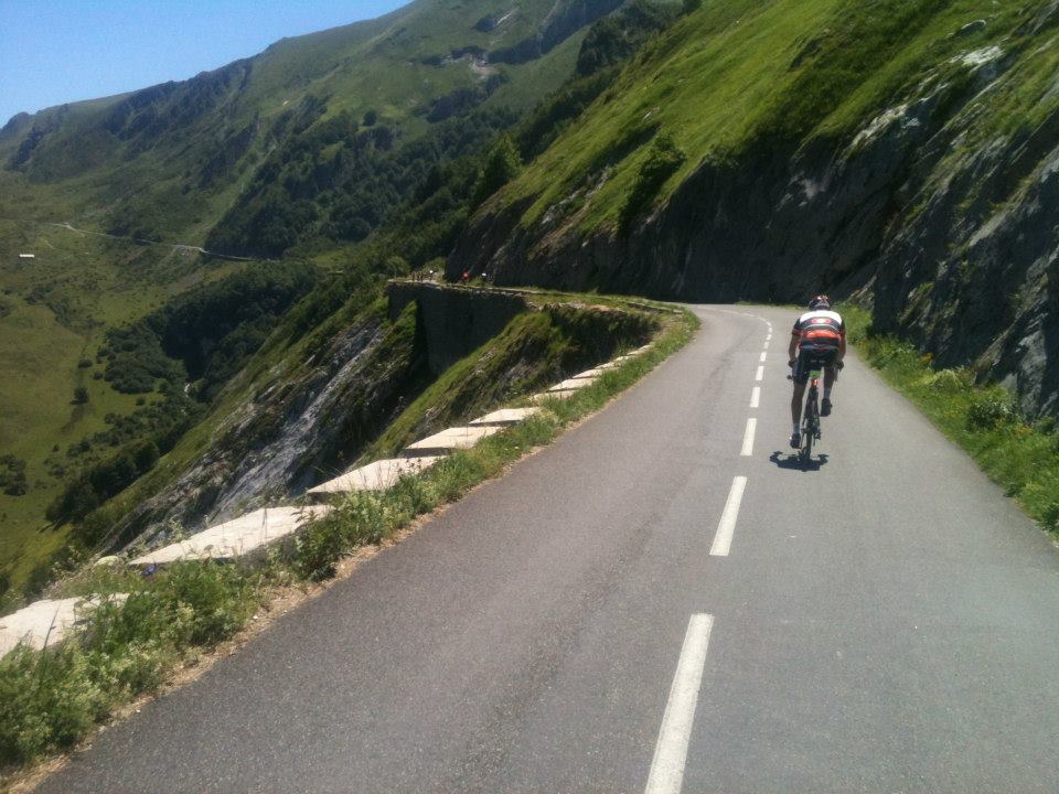
Col d’Aubisque (Pyrenees-Atlantiques / Hautes-Pyrenees)
Col d’Aubisque is a hors categorie climb which can be ridden from either the Pyrenees-Atlantiques (Laruns) or Hautes-Pyrenees (Argeles-Gazost). The Col d´Aubisque climb has been passed almost 50 times during the Tour de France making it the second or third most used climb in race history.
Most recreational cyclists attack this climb from Argeles-Gazost. To arrive at the Aubisque summit one most first pass Col du Soulor. Soulor is a cross-roads summit allowing you to continue straight to Col d’Aubisque. The road dips and corkscrews down for 2km bringing the overall climb percentage down.
What follows is the dramatic mountain road which links the Soulor and Aubisque summits. The road breathtakingly hugs the cliffs of the Cirque du Litor, passes two striking rock-blasted tunnels and is simply a cycling experience like none other. On reaching Aubisque take some time to soak up your great achievement and enjoy some fun photos with the giant TDF inspired bikes found at the summit!
The Aubisque to Soulor balcony road needs to be ridden to be believed!
The climb from the opposite direction begins in Laruns. Usually we have scaled the toughest side of Marie Blanque only 30 minutes earlier which can make Col’Aubisque really difficult. From Laruns you encounter a 16.6km climb, 1200m of elevation gain and 7% average grade. This side of the mountain does not have the same wow factor (no vertical cliffs) as you are hidden in dense vegetation. To take this one step further the forest is also often covered in thick mist and the roads can be quite wet. From the Gourette ski station there is only 4km to the Aubsique summit. While it may be sunny at the top on many occasions we have cycled through a layer of clouds around Gourette with extremely poor visibility. Please keep this in mind that the Pyrenees must be treated with respect and always have a bike light fitted and high visibility clothing available.
In the home straight to Col d’Aubisque having cycled from Laruns
Luz Ardiden (Hautes-Pyrenees)
Luz Ardiden is a ski station which sits high above the Luz-Saint-Sauveur township. Being the end of the road it has been used as a summit finish for the Tour de France and La Vuelta a España on 8 and 2 occasions respectively. Its 14km at 7.5% average grade makes it a hors categorie climb when added as the final piece of a grand tour stage puzzle. When the initial and final 2km present gentle 5% average grades it is clear that the middle 10km are going to constantly hit 8-9%. It is a climb that has been very popular since 1985 when the Tour de France first put it on the map.
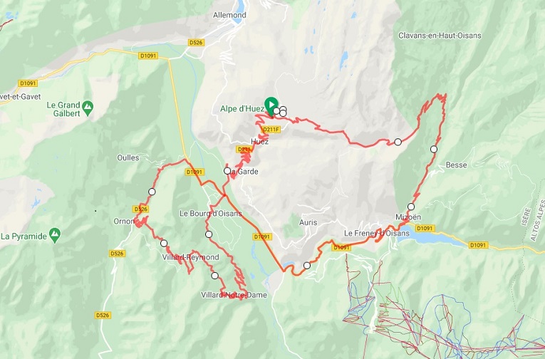
What we love about Luz Ardiden though are its 34 tight, beautiful switchbacks that hug the side of the mountain. Be sure to take plenty of photographs! When you consider that Alpe d’Huez has 21 famous bends over a similar distance, a clear day on Luz Ardiden is going to excite on many levels.
Cirque de Troumouse (Hautes-Pyrenees)
The Gavarnie National Park is best described as an oasis inside the oasis which is already the Pyrenees. Tourists usually come this far up the valley to visit Cirque de Gavarnie. This is a massive bowl-shaped mountain hollow that was the head of an ancient glacier and in 1997 it was awarded UNESCO world heritage status. It is the best known of the cirques in the region with its 6.5km diameter, its wall of 1.500 metres and the largest waterfall in Europe (427m).
But here we would like to showcase Cirque de Troumouse which is another ancient glacier which you can cycle all the way up to. ‘Troumouse’ is a gem. The climb is not one of the mythical TDF climbs as the Pyrenees National Park Authorities restrict race access to maintain the national parks pristine conditions and natural beauty!
The Cirque de Troumouse climb though is worthy of a Hors Categorie rating. The 31km climb with an average 5% gradient takes you up near the border between France and Spain. Really though it is 2 climbs in 1. From Luz Saint Sauveur you ride to Gedre. The initial 19km typically range from 2-5% average grade providing a perfect warm-up for what still remains!
Just out of Gedre it is time to veer off the main drag to the left and head in search of Troumouse. The final 12km present a number of stunning switchbacks and the most challenging part of the climb (average 7.5% grade). The Cirque itself now becomes visible and its beauty will carry you all the way to the summit!
We have also already talked about Gavarnie so if you have the legs descend back to the main road, turn left and keep riding up the valley road to Gavarnie township and the end of the road. If you have some support following you lock up your bikes and be sure to take a hike to the Gavarnie Cirque. There are marmottes to be spotted! Or for those of you in for a huge day of cycling then look no further than Col de Tentes (aka ‘Boucharo’). From Gavarnie there is still a further 10km of climbing up to 2208m elevation. If you complete both Tromouse and Tentes in the one day then you will have spent a classic day out on the bikes!
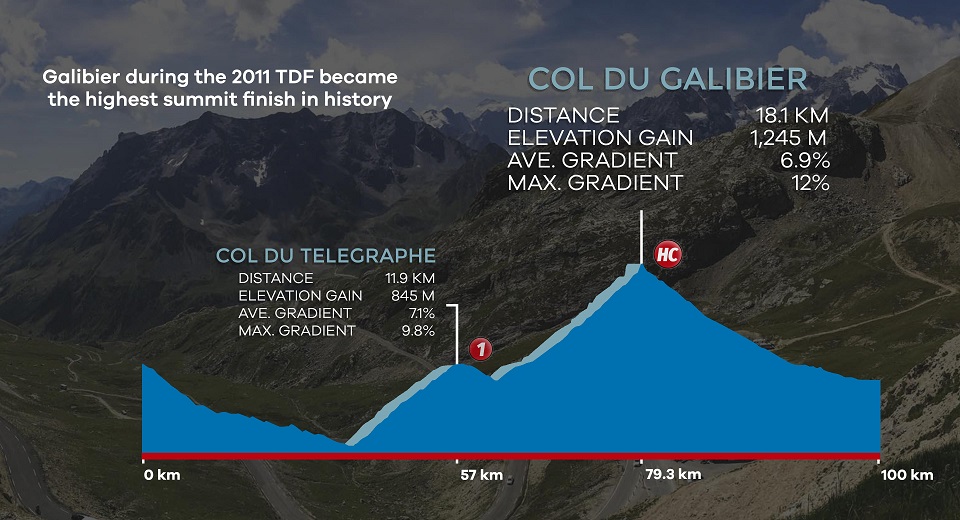
Col du Tourmalet (Hautes-Pyrenees)
The Tourmalet is always a favourite amongst recreational cyclists and this cycling mecca has currently been used on about 85 occasions during the Tour de France. The climb is going to be exhilarating no matter whether you climb from the west (Luz Saint Sauveur – 18km) or from the east (Campan – 19km).
Col du Tourmalet is another tough hors categorie climb but the eastern approach has a degree of difficulty a fraction higher than the western approach. The eastern climb out of Campan has the first 2km practically flat meaning the 8% average saves some tricky back-end kilometres. These difficult sections always seem to start to kick-in just as you pass through the first of the avalanche structures. From La Mongie ski station the mountain begins to open up and the sheer rock walls and epic switchbacks start to take effect. The views from the Tourmalet summit looking back towards La Mongie have provided some of our best moments when watching the Tour de France peloton race this beautiful mountain.
A highlight for everyone is greeting the giant structure (Geant) at the summit which is dedicated to Octave Lapize the first TDF cyclist to cross the Tourmalet during the TDF over a century ago (back in 1910). The giant cycling statue rests above the narrow rock cutting and where the compulsory group and individual photos are taken!
The Col du Tourmalet summit is one of the best places to watch the Tour de France
Cycling the Tourmalet from the west, on the other hand, means you will start in Luz Saint Sauveur. This is a small village which during the summer period is always lively and a great excuse for cyclists to hang-out for a beer post ride. The 18km climb at 7.5% average grade in our opinion provides the best overall Tourmalet experience. Why is that you ask? Well, if you like adventure then the chance exists to ride the ‘Voie Laurent Fignon’. Just after Bareges turn right onto the original D918 road which is open for cyclists only. Its narrow winding asphalted road still exhibit some faded TDF race markings and the views down to the valley below are simply unrivalled!
Exclusive Tourmalet cycling jersey by Sierra Sports & Tours
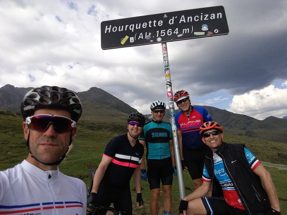
Ancizan is one of our favourite valleys with green lush pastures and very quiet roads for cycling. In fact, Hourquette comes from the Gascon word for farm and this road cycling detour passes by plenty of sheep, cattle and even donkeys roaming freely. For this reason, if descending the northern side towards Campan please take care of the animals and their roadside business!
It really is a climb with two totally different sets of statistics. The northern ascent from Campan includes 22.6km at 4% average grade. Please note that this includes the initial kilometres on Col d’Aspin before turning off to the right on the D113 road at Payolle. On the other hand, coming from the south and the township Ancizan the climb kicks up at a 7.8% average grade over 10.3km. If we are looking for a challenge we like to ride Hourquette d’Ancizan from the south and then Col du Tourmalet from Campan. Hitting up the most difficult sides of these two cols makes for an excellent cycling challenge!
Cycling Hourquette d’Ancizan from the difficult southern ascent
When it comes to Tour de France history this valley has only been ridden during the 2011, 2013, 2016 and 2019 race editions. Traditionally the Saint-Lary Soulan and Argeles Gazost towns were linked via the Col d’Aspin and Col du Tourmalet climb double. We think that Ancizan over the last decade has added a new dimension to Le Tour and will be used on many more occasions into the future.
Time for a photo on the Ancizan summit!
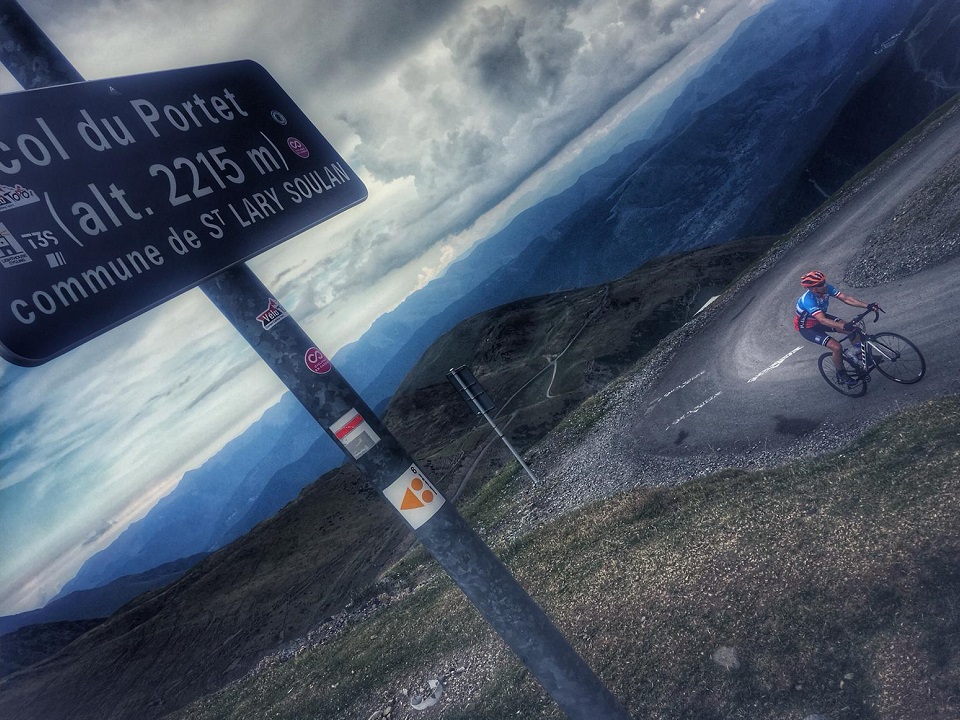
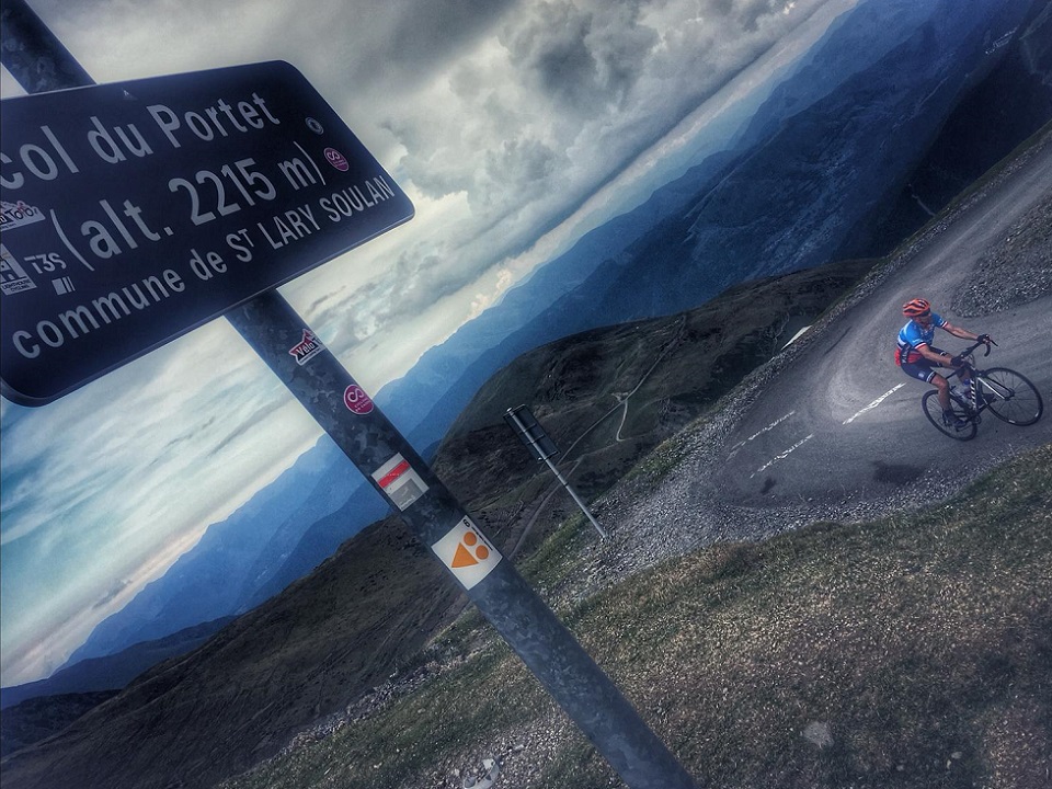
Col du Portet (Hautes-Pyrenees)
Col du Portet is perhaps now the most difficult cycling challenge in the Pyrenees. It was used for the first time during the 2018 Tour de France as a summit finish. The 16km climb at 8.7% average grade finishes at 2215m making it the highest asphalted pass in the Pyrenees. Move aside Tourmalet as Portet now owns the bragging rights!
The first 8km of the climb follow the road to Pla d’Adet ski station. The initial 4km are always hovering around 10% and need to be treated with full respect. The only reprieve comes between KM 7-8 where the gradient drops to an ‘easy’ 5%. Following this short transition to catch your breath you turn right to follow the Col du Portet signpost. Before 2018 this section was a gravel road but Le Tour brought along the roadwork crew to add some hot mix. As you pass the small tunnel it will serve as the final 1km marker and the 10% grade continues all the way to the summit!
If you haven’t seen any footage from this ‘new Pyrenees col’ then be sure to stay tuned for 14 July 2021 when it hosts the Stage 17 summit finish. From Bagneres-du-Luchon the peloton will climb Peyresourde and Val Louron-Azet before being faced with the new giant which is Col du Portet!
Col du Portet is the new highest asphalted col in the French Pyrenees
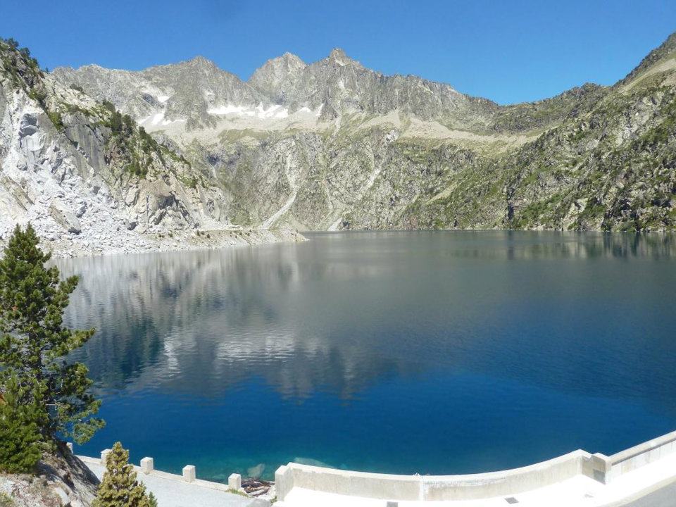
Cap-de-Long (Hautes-Pyrenees)
Not too far away from St-Lary Soulan lies Cap-de-Long yet another Pyrenees giant. Cap-de-Long is a mountain reservoir hovering at an astonishing 2160m altitude (France´s second highest reservoir). At the summit one is literally only a stone’s throw away from Spain. The Tour de France would love to have a stage finish here but the logistics just do not allow access for such a big event.
If we could ride only one col in the Pyrenees we would actually select Cap-de-Long! From St Lary you follow the main road towards Spain. This road quietly gains elevation so please keep that in mind. After about 10km you veer right and from here the col proper begins. Its statistics include 14km with a 7.5% average grade. When it comes to scenery we believe it offers the best climb for photography in the French Pyrenees. Woodlands, switchbacks and reservoirs dominate proceedings. This is one climb where you feel nature all around you during every single kilometre. Very special!
Some of the best road cycling switchbacks are found on Cap-the de-Long climb
As you ride out of the forest and past the first lake the huge dam wall enters your eyeline. This is Lac de Cap-de-Long and you now have the summit in sight. There are some roadside fountains along the way which during the hot Pyrenees summer come as a welcome relief.
Lac de Cap-de-Long
Even though the carpark at the summit is often desserted it really is a magnificent place to visit. What we like to do is descend 4km and take the left hand turn to a lower lake which is on the road to Lac d’Aumer. Here you can find a spot of grass for a picnic or to take a dip in the ‘fresh’ lake waters. If you still have some strength be sure to continue cycling up to Lac d’Aumer at 2191m elevation. It is a further 5km of climbing on a road closed to traffic so it is a very enjoyable way to conclude your ‘Route of the Lakes’.
Where to Start Cycling the Pyrenees
San Sebastian (Basque Country, Spain)
It might seem strange to kick things off with a Spanish coastal town but who does not love a bit of San Sebastian action. In our opinion, it is the perfect place to begin or conclude a cycling holiday. From ‘San Seb’ (Donostia in Basque) you will need a vehicle to easily move into the thick of the Pyrenees-Atlantiques.
Following a 2hr 15min or 2hr 30min drive you will find yourselves in Arette or Laruns respectively and at the base of some sleeping road cycling giants. Stage 10 of the 2015 Tour de France saw Chris Froome put minutes into his biggest rivals by winning at the top of La Pierre-Saint-Martin (15km at 7.4%) from Arette.
When it comes to Laruns, more recently Tadej Pogacar won Stage 9 of the 2020 Tour de France with a sprint finish in Laruns after a select group battled out the ‘hellish wall’ which is the western side of Col de Marie Blanque. At the exit of this sleepy township you also have the choice of either Col du Pourtalet or Col d’Aubisque which rise up for what seems like an eternity before reaching their respective summits!
Toulouse (France)
The fabulous city of Toulouse will probably be the most likely point of entry for most travellers looking to collect cols in the French Pyrenees. It is located within the Midi-Pyrenees department and from Toulouse Blagnac International Airport there is a 2hr drive to Lourdes in the Hautes-Pyrenees.
From Toulouse Blagnac Airport there is a 20 minute shuttle bus to the Toulouse Matabiau Gare SNCF bus stop. From the bus stop it is just an easy few minutes walk to Toulouse Matabiau Train Station and now in as little as 1hr 45min there are train options to Gare de Lourdes.
Lourdes (France)
While most of the flights coming into Tarbes-Lourdes-Pyrenees Airport are charter flights (pilgrim focus) there are still some internal European passenger flights available. TLP Airport is located only 15km north of Lourdes. At the time of writing we understand that there are Air France, RyanAir, TUI and AlbaStar flights to Lourdes from destinations such as Paris-Orly, Dublin, London Stansted, Bergamo, Milan and Lisbon. Please double check directly with these airlines though as flight offerings are limited and can be very seasonal.
Gare de Lourdes is also a location where we have collected and said our goodbyes to many clients who have cycled with us in the French Pyrenees. Lourdes is on the TGV fast train lie between Paris Montparnasse and Tarbes. The fast train from Paris takes approximately 5hr while if you were to jump on from Bordeaux it would be closer to 2hr 30min through to Lourdes.
Where to Stay when cycling in the Pyrenees
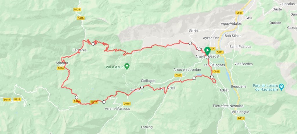
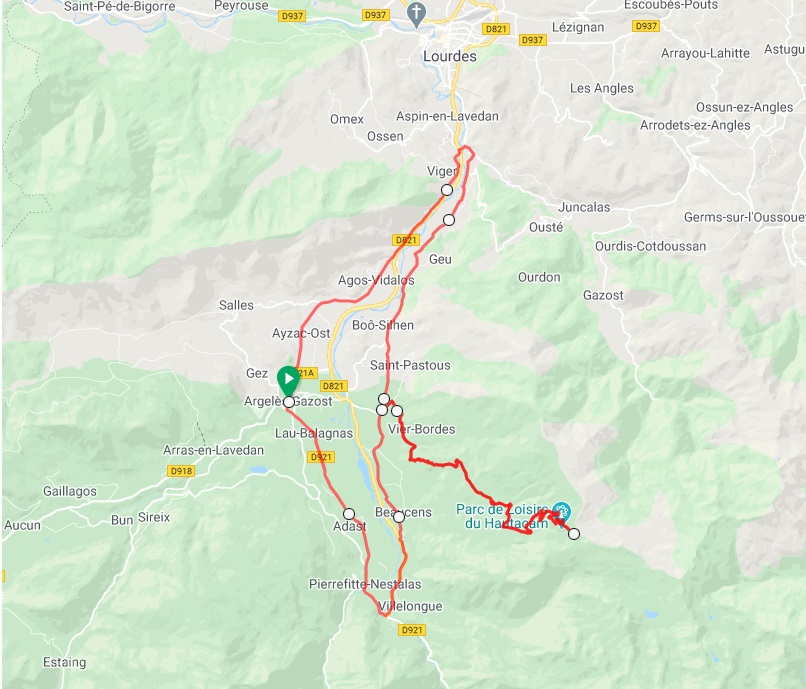
Argeles Gazost the heart of the Hautes-Pyrenees
Argeles-Gazost is located in the heart of the Midi-Pyrenees and is a brilliant location to start any mountain experience. You will always find a place to sleep in nearby Lourdes but for cyclists we would have to recommend Argeles.
Argeles-Gazost is a quaint little town and an amazing cycling base with famous Tour de France routes at every corner. To name a few cols and you have access to Soulor, Aubisque, Spandelles, Hautacam, Luz Ardiden and Tourmalet.
We have already talked about the Soulor/Aubisque double. But from Argeles you can also ride Col du Spandelles, descend and later turn left and head back up to the Solour/Aubisque junction. This is a challenging loop ride as the Soulor climb following the road from Pau does get steep in place.
Col du Spandelles loop ride from Argeles Gazost (57km / 2050m elevation gain)
From Argeles it is also possible to follow the designated bike path to the ´Gorges de Luz´ entrance. This gorge is a spectacular 10km section of road steeped in Tour de France history as it connects the Soulor / Aubisque and Tourmalet / Luz Ardiden climbs.
The Hautacam is another classic climb on the outskirts of Argeles. It is not as beautiful as some of the other climbs but geez it’s tough. On a clear day from the valley floor you can see the towering Hautacam ski station. Many believe it is the toughest climb in the midi-Pyrenees region! Now that is saying something when it competes with Tourmalet, Luz Ardiden and Aubisque! The 13.5km climb averages 8% but the damage is often done during Km 8 -10 where the grade does not drop below 10%. We will always remember Vicenzo Nibali and his solo effort during Stage 18 of the 2014 TDF to take line honours on Hautacam!
Hautacam ride from Argeles Gazost (55km / 1570m elevation gain)
When you arrive at the large parking area at the Hautacam summit it is good to know that Col de Tramassel also exists. This is a 1.5km add-on which is worth the effort.
Another adjacent town to consider is Saint Savin. It is a sleepy village that is very well set up with a number of bike friendly accommodation options.
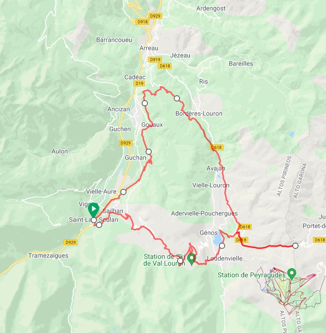
Saint-Lary-Soulan
St Lary is one of our favourite French towns with its pretty ‘centre ville’ and exceptional access to outdoor sports. With mountains to climb in all directions it is the perfect base for road cyclists! If you are keen to tick-off a number of the big cycling cols then this is your place. Pla d’Adet, Col du Portet, Col d’Azet, Col du Peyresourde, Cap d’Long, Piau Engaly, Col d’Aspin and Hourquette d’Ancizan …..
Col du Peyresourde loop ride from Saint-Lary-Soulan (50km / 2020m elevation gain)
Bagneres-du-Luchon
This Pyrenees township is famous for its thermal waters. It is located close to the Spanish border and is a regular feature in the Tour de France. There are some quality cols all around and some of our favourites include Col du Portillon, Superbagneres, Col du Peyresourde and Port de Bales.
Col du Portillon is on the France/Spain border and if you are descending down into Bagneres please take some care. We believe it is one of the most technical descents in the Pyrenees. Adam Yates was all alone and set for his first TDF stage win before crashing out heavily during Stage 16 of the 2018 TDF.
Many classic Tour de France stages also link between Saint-Lary-Soulan and Bagneres-du-Luchon. These towns play a vital part in Le Tour and the Col du Peyresourde climb is a regular feature. Cycling Col du Peyresourde from Bagneres provides some epic switchbacks in the final 2km. Just when you think you are at the summit the switchbacks seem to take you further away again! Spectacular views are on offer from all vantage points and the chance to stop for a well earnt crepe atop Peyresourde awaits!
List of Epic Cols in the French Pyrenees
Moving from west to east along the Pyrenees mountain range and here is a list of cycling cols:
Pyrenees-Atlantiques: Col de Marie Blanque, Col de la Pierre Saint-Martin, Col du Somport, Col d’Aubisque and Port de Larrau.
Hautes-Pyrenees: Col du Tourmalet, Col du Soulor, Hautacam, Luz Ardiden, Col de Tentes, Cirque de Troumouse, Pont d’Espagne, Col de Spandelles, Col d’Aubisque from Argeles-Gazost, Col des Borderes, Col de Couraduque, Hourquette d’Ancizan, Col d’Aspin, Col de Peyresourde from Arreau, Peyragudes, Col du Portet, Pla d’Adet, Col de Val Louron-Azet, Piau-Engaly and Cap-de-Long.
Haute-Garonne: Col du Peyresourde from Bagneres-du-Luchon, Port de Bales, Col du Portillon, Superbagneres, Col de Mente and Portet Aspet.
Ariege-Pyrenees: Port de Pailheres, Ax-3-Domaines, Col d’Agnes, Col de la Core, Col de Latrape and Col du Chioula. This is quite a small region and has not been covered in this blog.
Pyrenees-Orientales: This region is often referred to as the Pyrenees-Catalanes and is the most eastern region of the Pyrenees. This zone, like the Ariege-Pyrenees, has not been covered in this blog.
Andorra: An interesting side note surrounds Port d’Envalira which is 5km within Andorra from the French border and which rises to 2409m altitude actually making it the highest asphalt pass in the Pyrenees! Again, not covered here but well worth a Andorra cycling blog feature for a later date.
Just over a week ago the 2021 Strade Bianche races provided more amazing cycling footage from Tuscany. Naturally, the white gravel roads again played centre stage. It is no secret that the crew here at Sierra love to get off-road. It was back in 2014 when Sierra first started guiding our cycling tour groups over the ‘strada bianca’. At first, some of our guests probably thought the concept of gravel cycling in Tuscany was a little crazy. But right from the start we were sure we had found a winning combination!
Sierra guests were riding gravel before it became COOL!
Sierra Sports has always looked for some white gravel for our Giro d’Italia tours
Gravel cycling from the Giro to l’Eroica
You see, in Tuscany, the gravel roads provide cyclists with a huge amount of flexibility. Hard compacted gravel can lead you up to picnic lunches in remote hilltop villages. Cruising along ridgelines provide super vantage points that look out to medieval cities like Siena. Plus gravel detours offer up the chance to beat Giro d’Italia road closures. We fondly remember bush-bashing to within metres of an individual time trial start in Chianti wine region.
The Tuscan gravel can basically take you anywhere you need to go!
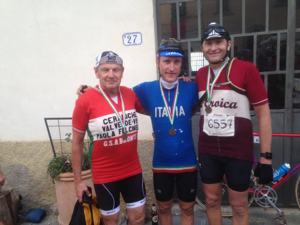
After a couple of Giro d’Italia tours rolled by we decided that we needed more Vitamin G. So with that came the birth of our l’Eroica vintage bikeadventures. We have been able to even spot Italian pro-riders cycling this event incognito behind their own vintage bike and woolen clothing disguises. Enrico Gasparotti won the 2016 Amstel Gold Race and only a few months later was enjoying the l’Eroica cycling festival with a relaxed ride with friends. Never in his wildest of dreams did he imagine a photo with the Sierra peloton at the finish line. Or should that be the Sierra paparazzi!!. It all amounts to a very special day when you see a current pro-rider wearing l’Eroica finisher medal with so much pride!
Roger, Enrico & Jeff enjoying l’Eroica post-ride celebrations!
Tuscan gravel cycling goes vintage
Cycling the gravel roads also gives us adults the chance to dress-up for a day. It turns into a bit of a competition around who can go most vintage. Finding a retro jersey is easy at l’Eroica vintage market. To give you an idea, this vintage bike market is a bit like Pick-a-Part for second-hand car accessories. Sierra owner Paul back in his maiden l’Eroica trip stumbled across the ‘GSR Camping Citta Di Angera’ woolen classic. He fell in love at first sight. Note the green and gold colours!
Woolen cycling jerseys are all the rage at l’Eroica!
What happened next and what continues to happen every year is local Italians gravitate to the jersey. It just seems that most of central Italy love the Angera camp ground. We later found out that this camping is located on the shores of Lago Maggiore just north-west of Milan. If Paul could pull off an authentic Italian accent (rather than his Spanish one) then he could try to pass as the camp ground owner. On average there would be 5 riders every year that come up and tell Paul just how good ‘GSR Camping Citta Di Angera’ really is. As a result, we have made a note to check it out one day with the family!
Prosecco in Chianti wine region
The best feature of the jersey though is by far the extra large and reinforced back pockets. As you can see in the above photo, a bottle of prosecco wine easily fits in! So the handover of a bottle or two of crisp Prosecco just on the entry to Gaiole in Chianti is now tradition. This way we make sure our gravel cycling in Tuscany experiences are celebrated in style!
Don’t worry though, we make sure to also sample the local Chianti wines. There is plenty of time for a quality glass of red while telling tall tales. l’Eroica will do that too you! What a way to mix Tuscan gravel roads, vintage bikes and cycling culture. The gastronomy combined with friendly locals willing to share their small towns will create your best ever Italian travel experience. Feel free to follow this link if you would like to learn more about our Tuscany & l’Eroica cycling holidays. Viva la Toscana!
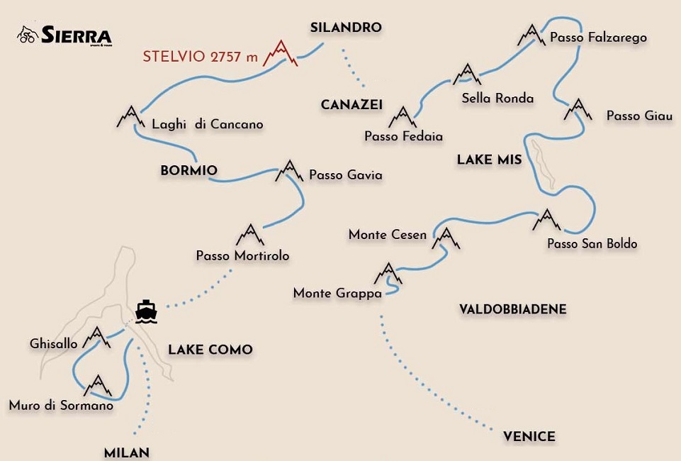
Welcome to the roads of cycling legends! The northern region of Italy is dominated by several high mountain ranges which share borders with France, Switzerland, Austria and Slovenia. In the north-western corner is Valle d’Aosta and we actually covered a number of the famous road cycling climbs, such as, Sestrieres, Colle delle Finestre, Mont Cenis and Col de Montgenevre in our French Alps cycling web-guide. To the north-east is the Carnic Alps which border Slovenia and where the 2020 Giro d’Italia explored the Italian Fruili region. Click here for a cycling travel itinerary between Fruili and Slovenia.
However, when it comes to major Italian road cycling interest it is the Dolomites and Stelvio National Parks which always capture the most imagination and these two regions are featured in this blog. There are many incredible mountain passes to be conquered in the Italian Alps and the two regions are really only separated by a 2 hour drive when moving from Canazei (western section of the Dolomites) to Silandro (to the east of the Stelvio National Park).
In this blog we share our road cycling knowledge and offer suggestions on where to start your Italian Alps cycling holiday, the famous ‘passes’ on offer, some of our favourite cycling routes including profiles and options of where to base yourself to get the most out of your cycling adventure.
Venice is a favourite travel destination for so many and a great place to also kick-off an Italian cycling holiday. The roads leading out of Veneto cross into the pre-Alps and the views to the limestone peaks show that the Dolomites are so tantalizing close.
If you are going to spend some time looking around Veneto the Prosecco Wine Region is a good starting point and some classic Giro d’Italia climbs, such as, Monte Grappa and San Boldo Pass will get you well and truly warmed-up for the Dolomites. All of this is only a 45-60 minute drive away from Venice.
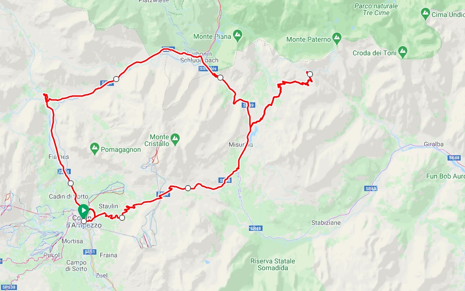
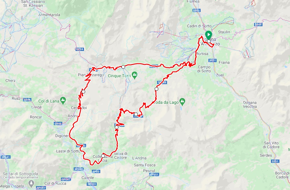
From Venice a 2hr drive will find you in Cortina d’Ampezzo a hot spot for outdoor winter and summer activities in the Dolomites. Passo Tre Croci, Tre Cime di Lavaredo, Passo Giau and Passo Falzarego are just a few of the immediately accessible climbs. In addition, to find yourself on the Sella Ronda cycling route one can drive approx. 2.5hr from Venice and be settled in Canazei, Arraba or Corvara and ready for some Dolomites cycling action.
To arrive in Venice you will be booking your flights into Marco Polo International Airport.
Milan (Italy)
Milan is another major centre for international travellers. By arriving in Milan the Stelvio National Park is closer so we suggest moving across northern Italy from west to east where you could later finish up with some Dolomites cycling routes. If you would like a cycling intro to break you into the swing of things from Milan we would recommend a visit to Lake Como first.
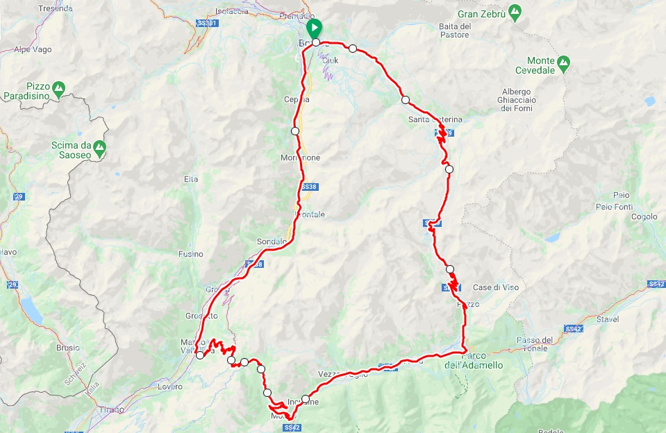
Como and Bellagio are only 45 minute and 1.5hr drives respectively from Milan Malpensa Airport and the region is home to the roads of the Giro di Lombardia (5th European cycling monument race). However, for those who want the big stuff straight away then you can arrive directly beneath the Italian giant climbs of Gavia and Stelvio with a 3.5hr drive from Milan to Bormio. Bormio much like ‘Cortina’ (Dolomites) is a major ski centre and is also a great base for summer cycling adventures.
Most international travellers arrive into Milan Malpensa which is the largest international airport in the metropolitan region. If you need to move between the Milan city centre and Malpensa airport the easiest way is to take an airport express train or bus which usually takes about 30-45 minutes.
Bolzano (Italy)
If your flight connections allow you to arrive to Bolzano airport then this is only a 1hr 15min drive east to Canazei on the western fringe of the Dolomites. Canazei is a lively town located immediately below the junction between Passo Sella and Passo Pordoi on the Sella Ronda cycling route. In addition, from Canazei the famous Passo di Fedaia climb from the Giro d’Italia is available which culminates up at the amazing Fedaia lake.
If you are lucky with a clear day then the lake provides an incredible vantage point to marvel at the Marmolada glacier which is the highest peak in the Dolomites.
In addition, if you drive 1hr 15min to the west of Bolzano Airport you will find yourself in Prato Allo Stelvio township which sits below the Stelvio Pass. Here you will have access to the northern approach with its legendary 48 tornantes (switchbacks).
Zurich (Switzerland)
If some time in Switzerland also sounds appealing then Zurich is another option. Before arriving to Bormio which is a 4.5hr drive from Zurich why not make a stop off in St Moritz which is half-way on the journey. This high-profile alpine resort at 1822m elevation provides a blend of glamour, lifestyle, sport and pristine nature. You will also have the chance to sneak in some Swiss altitude training before taking on the Stelvio Pass!!
Bucket-list Road Cycling Passes
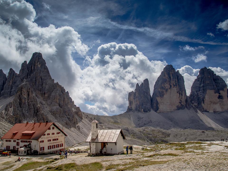
Now it is time to feature some of the truly great Italian Alps bucket-list cycling climbs. Over the last decade we have cycled the Dolomites National Park and Stelvio National Park regions year after year and can vouch for the amazing recreational and travel experiences on offer. In no particular order but cycling the Italian Alps means the following climbs, amongst many others, will be all yours – Passo Pordoi, Passo Giau, Passo Fedaia, Tre Cime di Lavaredo, Passo di Gavia, Umbrail Pass and Stelvio Pass!
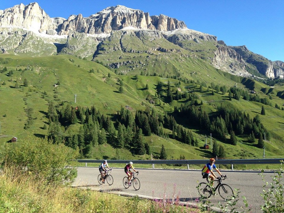
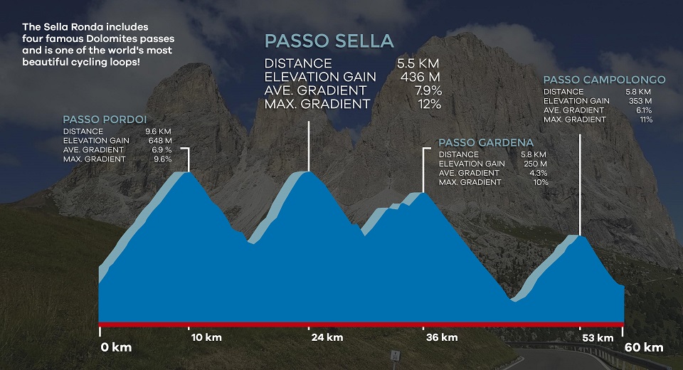
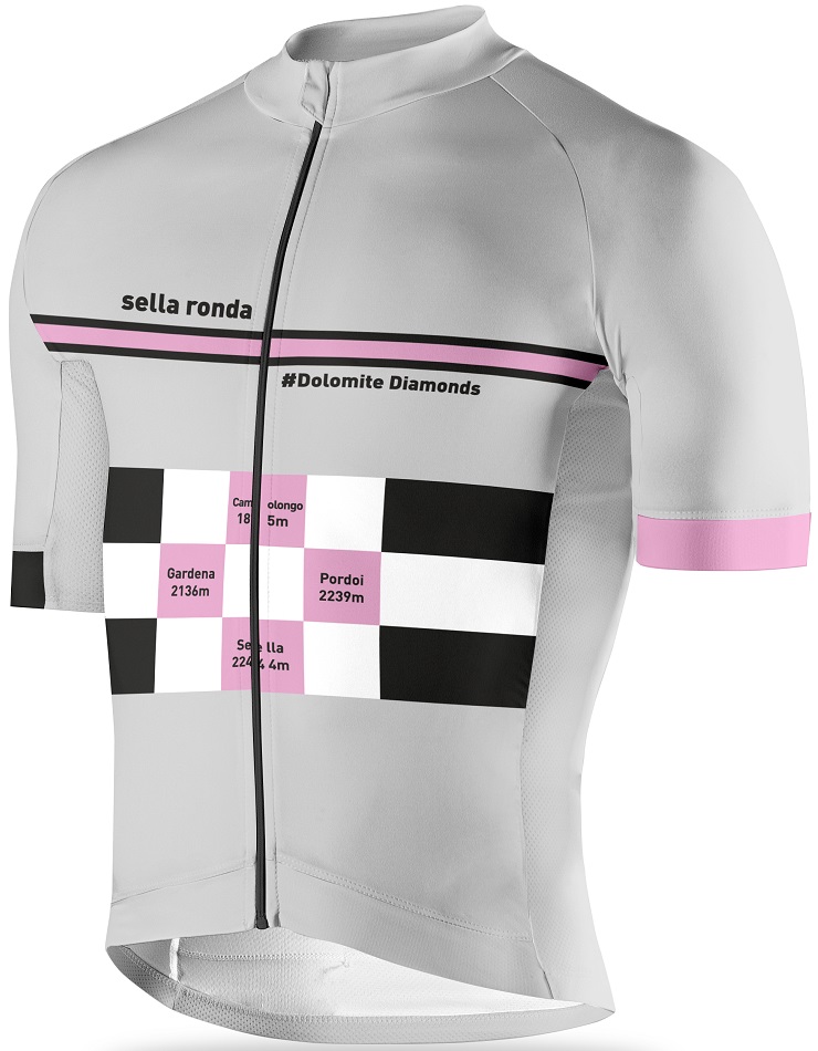
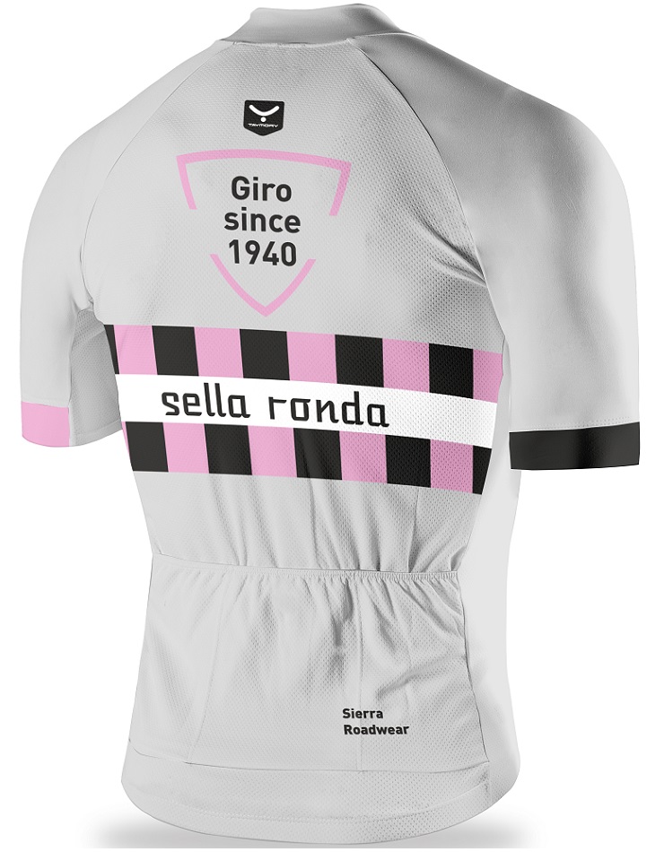
Sella Ronda (Dolomites)
The Sella Ronda loop is one of the world´s most iconic cycling destinations thanks to its 4 climbs in one cycling route. It is a must for any cyclist who visits the towering Dolomites mountain region. There are 4 steps to become a member of the Sella Ronda club: Passo Pordoi, Passo Sella, Passo Gardena and Passo Campolongo. The views of the jagged limestone peaks, pine forests, alpine meadows and winding roads will be etched into your memory for a lifetime!
Passo Pordoi: 9.2 km, Gradient: 6.9%
Passo Sella: 5.5 km, Gradient: 7.9%
Passo Gardena: 5.8 km, Gradient: 4.3%
Passo Campolongo: 5.8 km, Gradient: 6.1%
The four above climbs are all jam-packed into a circular route that measures no more than 60km. Don´t let the relatively low kilometre count trick you though as each pass goes accumulating elevation, almost 1850m of elevation gain! The Sella Ronda is the core of the ‘Maratona dles Dolomites’ gran fondo cycling event. 9000 riders line up every year to tackle the Maratona which is described by National Geographic as “one of the biggest, most passionate, and most chaotic bike races on Earth”. Riding around the Sella Massif is about as good as it gets for mountain scenery!
For most cyclists who have travelled Italy in and out ‘Passo Giau’ will be in their top 10 favourite cycling climbs. Giro d’Italia tragics will have especially heard about the southern approach of Passo Giau from Selva di Cadore. This Dolomites beauty measures 10.1km and the 9.1% average grade takes you up to 2236 metres elevation.
We typically access the Passo Giau (south) climb when we are already based in Arabba or when we arrive to the Dolomites from Caprile. Riding from either of these locations provide the perfect chance to complete ‘Giau’ and enter deep into the heart of the Dolomites national park. Just like Alpe d´Huez in the French Alpes, Km 1 of ‘Passo Giau south’ is its toughest with ramps constantly reading 10-12%.
At the summit you will be in awe of the seemingly sculptured mountain peaks surrounding you (Nuvolau, Lastoni del Formin, Cernera, Croda da Lago and Tofane). Passo Giau has been chosen various times as the Cima Coppi (the highest peak) in the Giro d’Italia cycling race. It is the highest mountain pass in the Cortina area and when combined with Colle Santa Lucia, Passo Falzarego or Passo Tre Croci it definitely makes for a Queen stage through the Dolomites. To find out some more about these other adjacent climbs please read later under ‘Cortina d’Ampezzo’ in our Where to Stay section.
Riding from the Cortina direction the Passo Giau ‘north’ ascent is also not without its own challenges. From Pocol the road tilts up and the 8.6km at 8.3% average grade winds its way through lush green fields and meadows filled with grazing cows. There are many sections with 6-8% grades making it a little friendlier than the slightly tougher’ southern approach.
Passo Fedaia (Dolomites)
Passo Fedaia is another classic Giro d’Italia climb in the Dolomites and it was last used during the Queen Stage 14 of the 2018 Giro d’Italia. To make things really interesting we enjoy riding ‘Passo Fedaia’ from the east which takes you initially through the Sottoguda canyon (Serrai di Sottoguda). From Caprile there is 5km to the Sottoguda township which in itself averages 4% along the winding main road.
Turn off into the Sottoguda township and pay the 2 Euro fee to enter this wonderful gorge as it is well worth it. A narrow road with small waterfalls which freeze over in winter is something really unique. This is also a one-way cycling road (up, up and up only for cyclists) which links you back to the main Passo Fedaia road. The canyon detour is the best option as you avoid the tunnel on the main road.
The final 9km from Sottoguda average 9% up to the 2057m summit and several 12-17% ramps are real leg zappers. But the majestic Lago di Fedaia lake at the summit is the prize and it may even seem familiar to you seeing it was used as the backdrop to the ‘Italian Job’ movie.
The western approach from Canazei is another quality climb. The ride measures 11.5km and the climb averages 6%. However, it is the final 4km where the grade hovers between 8-10% which will be the real test. At the top of the Fedaia pass there will be time to soak up the enormity of the Marmolada glacier which at 3343m elevation is the highest peak in the Dolomites. Talk about the perfect backdrop for a photo to remember!
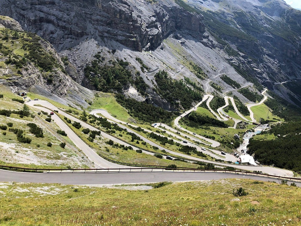
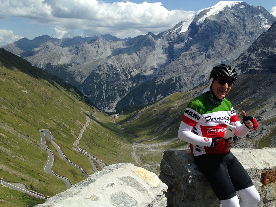
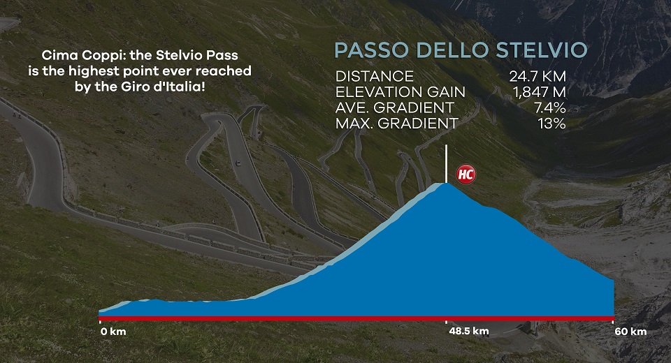
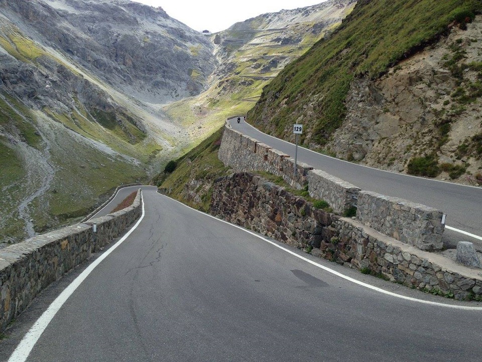
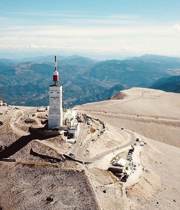
Passo dello Stelvio (Stelvio National Park)
Passo Stelvio (2758m) is the highest asphalted mountain pass in the Eastern Alpes, second only to Col de l’Iseran (2770m) in the French Alpes in elevation and with more than twice the number of switchbacks as the famous Alpe d’ Huez. The climb is epic in every sense of the definition.
The north side of the Stelvio is the iconic, legendary climb from the Giro d’Italia. 7 of its 12 passings have been held during either Stage 20 or 21 highlighting its importance. With the Giro race held every May the norm is to watch the pro peloton climbing alongside walls of snow elevating it to a level of epic which is unparalled to the other two Grand Tour cycling races like the Tour de France or La Vuelta a España.
The mythical Stelvio north side with its 48 hairpin bends rise up and up for 25km and gain 1840 metres of elevation. The climb begins on exiting the Prato Allo Stelvio township but we usually like to begin from either Silandro or Glorenza.
Glorenza is a beautiful small town and by starting here there is a very friendly 10km warm-up ride to have you ready for what is just around the corner. From Silandro you can also ride along the bike path to the base of the Stelvio Pass. This path is predominantly asphalted however there are some gravel sections which in our experience are no problem for road bikes. Past guests of ours have found this 20km through the apple orchards and woodlands as a welcome ‘Stelvio’ warm-up.
As mentioned above, when it comes to Giro d’Italia history, the Stelvio Pass has been contested on 12 occasions. It first appeared in 1953 when during the penultimate stage the Italian legend Fausto Coppi attacked on the Stelvio Pass to take the lead and secure victory in Bormio. This guy Coppi was pretty good right! This would be his fifth and final Giro title and all thanks to the Stelvio.
Did you know that in 1952 the Tour de France first rolled out Alpe d’Huez? Well the Giro d’Italia retailiated the following year by showcasing the Stelvio Pass which has now become a true test for all avid recreational road cyclists. At the top be sure to take a bow to his majesty the Stelvio Pass. Your sense of achievement will be at an all-time high!
Stelvio Pass can also be attacked from Bormio village and more information on this ascent can be found later under Bormio in our Where to Stay section.
Just like the Stelvio Pass, Passo di Gavia (2621m) also rises out of the Bormio sport village. This is just another mythical climb that has crowned many modern-day Giro d´Italia winners! ´Gavia´ with its 1400 metres elevation gain over 25km leaves one short of breath (5.5% average grade). From Bormio the climb begins as a major road accessing ski villages which then changes in a blink of an eye to a narrow remote mountain road which passes eerily through forest and later up into a barren glacier field.
The ‘real’ Gavia road begins at Km 12.5 with the first right hand switchback out of Santa Caterina ski village. We guarantee that you´ll never forget its tight switchbacks and steep ramps! Apart from all of its challenges we are always amazed to watch cyclists time trial the final two kilometres around the lake to the summit on a false flat!
Km 0 – 6: Gradient: 2.5%
Km 6 – 12.5: Gradient: 6.0%
Km 12.5 – 23: Gradient: 7.4%
Km 23 – 25.6: Gradient: 3.5%
Moving away from Bormio and the Gavia cycling assault from Ponte di Legno is also a truly epic and rewarding climb. This is a 17km climb with a 7.9% average grade and includes 15 switchbacks which will forever be carved into your memory. The initial 3.5km are relatively straightforward but from there on expect 7-10% average kilometre grades with a couple of 13% and 14% ramps just for good measure. It is a good idea to have bike lights as near the top you pass through a tunnel. The final 3 switchbacks near the summit tightly twist up the mountain and the precipitous view down over Lago Nero is simply awesome!
Whichever way you climb to get there (Bormio or Ponte di Legno) the Gavia summit is a remarkable location and you will have to deal with its forever changing gradients. Near the summit you find the beautiful Lago Bianco with the Corno dei Tre Signori mountain (3359m) keeping guard. And right at the top the glacier means the temperature at this elevation are always quite low even in the middle of the summer. Jump into the family owned cafeteria (rifugio) for a nice hot chocolate or coffee!
Since 1960 there have been 10 Giro d’Italia crossings. Interestingly enough though the Gavia has also seen several race cancellations due to terrible weather conditions (1961, 1984 and 2013). Since the mid-1990s the Giro has scheduled 8 of its 10 Gavia crossings highlighting the desire of the modern race organisers to showcase this cycling giant as a true ‘Cima Coppi’ for the highest point in the race!
For some the Gavia climb is actually more difficult than Stelvio Pass due to its UNPREDICTABILITY. Stelvio is an engineered modern road, almost a mountain highway. The Gavia though is a lesser trafficked road which is often closed for longer periods of the year. The quality of the asphalt is poorer (in places really broken up), its rougher, the road widens and narrows, the switchback corners viciously ramp up rather than flattening and the weather is usually more extreme. Battling between how to ride the alternating flatter and steeper grades sees many riders push too hard before even entering the difficult upper sections of this famous mountain road.
Cycling Routes & Where to Stay
When considering cycling the Italian Alps you must first decide if you are looking to ride the Stelvio National Park, the Dolomites or both! If you are looking at combining the two regions then this will involve some strong legs and a sufficient amount of time to make sure your cycling holiday is not too rushed. If your aim is to ride both regions we would also recommend a vehicle to safely move you between these two cycling meccas and to also maximise the number of epic days of cycling available.
When looking at the Dolomites also remember that the Prosecco wine region is an excellent option for getting started on the bike. At the same time, Lake Como or the roads around St Moritz (Switzerland) will also provide a fantastic introduction leading you to the challenges that await in the Stelvio National Park.
Valdobbiadene (quick stop before the Dolomites)
If you have decided to arrive to Venice and want to put in some cycling before hitting up the Dolomites then keep Valdobbiadene on your radar. While it is not the Dolomites there are a number of brilliant loop rides through the rolling hills of the Prosecco and Cartize wine area. Following the landscapes of Italy’s prized sparkling wine is always a major highlight.
For those looking for a challenge then Monte Cesen which soars above Valdobbiadene, capital of Prosecco wine region, will break up any vineyard spin. The 18km climb at 7% average takes you up through the forest before passing the treeline and presenting its expansive views over the Veneto valley. This is a great test to judge if your legs are going to be ready for the nearby Dolomites. Travel is also all about combining great food and wine and a couple of nights in Valdobbiadene means you will be able to trial some of its fantastic agriturismo restaurants.
Any riding in the pre-Dolomites should also be sure to include Passo San Boldo. The road near the summit includes a series of five switchback tunnels carved into the rock! The 6km climb at 7.5% average was last contested during Stage 19 of the 2019 Giro d’Italia which an emotional Esteban Chaves went on to win! Rolling across the top of the plateau offers incredible views to the Dolomites. Is that snow we often get asked? No, there you have the limestone peaks of the soaring Dolomites which will now be your next stop!
Cortina d’Ampezzo (Dolomites)
Cortina is well renowned as one of the premiere ski villages in the Dolomites. It has even been selected to host the 2021 ski world championships and the 2026 winter olympic games. But as the snow begins to melt and the mountain passes open up the road cyclists return to Cortina in their droves.
From Cortina one of our favourite rides begins with the Passo Tre Croci climb (8km and 7.3% average grade). The majestic Lake Misurina rests near the top of the climb at a staggering 1760m elevation and is the perfect place for a coffee or lunch stop. For those who would like an added challenge why not try your hand at the final 7km ascent to Tre Cime Lavaredo (average 8% grade). The numbers do not tell the true story though as the final 4km average 12%.
On arriving to the Auronzo Refuge at 2300m the sheer size and beauty of the ‘Tre Cime’ Dolomites rock formation will take over! If you want to take longer to enjoy Lago di Misurina then please avoid the brutal climb up to Tre Cime di Lavaredo and just continue the cycling loop back to Cortina. The short loop includes 40km and 1000m of climbing while the total loop ride up to Tre Cime measures 55km and 1575m elevation gain.
As we mentioned earlier, from Cortina it is also only a short ride to Pocol and access to ‘Passo Giau north’ if you are looking for a simple straight out and back ride option. For those wanting another loop ride then we recommend following an epic Cortina ride which combines Passo Falzarego (10km at 5% average grade) and Passo Giau south. Again the distance at 65km does not sound overly taxing but the 2125m elevation gain is a solid workout!
It is also possible to move Dolomites cycling bases by riding from Cortina to other nearby towns, such as, Arabba or Corvara. The rides to Arraba and Corvara both measure approximately 35km and and include 1100m elevation. Both routes need to first cross Passo Falzarego. Arabba: from the summit follow the directions towards Caprile and after 10km of descent follow the signs to Arabba. Corvara: from the summit continue on another 1.5km and pick-up Passo Valparola as well before the long decent. 5km from Corvara turn off and cruise your way into town.
There may be some riders out there who have also heard of the mighty Monte Zoncolan climb. From Cortina it is a 2hr drive to Ovaro (at the base of Zoncolan) and while a long day trip it is still possible with an early start to ride what we think is within the top 3 toughest asphalted climbs in Europe. With climb statistics that put it in the same league as Mortirolo (Italy) or Angliru (Spain) it is one ‘out and out’ challenge.
The western approach from Ovaro is considered the most difficult – 10.5km with an average grade of 11.5%. The final 6km though average 15% with a maximum ramp of 20%. The eastern approach is not that much easier, however, its 13.5km with an average grade of 9% look a lot more achievable on paper. The final 3km though average 13% and an 80m ramp of 27% still lurks only 1.5km from the top. This Zoncolan climb should only be attempted by those cyclists who are keen to test themselves on an authentic Italian wall.
Arabba, Corvara or Canazei (Dolomites)
Any of these three towns nestled in the heart of the Dolomites are well placed for your chance to ride the four categorised climbs which make up the Sella Ronda. Arabba is the smallest of the towns and has more of a village feel about it. There are only a couple of restaurant options, a small supermarket and no bike shops at the time of writing. At 1600m elevation and with high mountain escarpments all around it really feels like you are staying in the heart of the mountains.
Canazei and Corvara are quite similar in size (bigger than Arabba) and have a lot more dining, bars and shopping options including bike hire and ski/bike related shops. Canazei at 1450m and Corvara at 1570m are both at altitude but with extensive green fields immediately surrounding the townships the feeling of a high mountain ski resort is not as strong as Arabba in our opinion. Corvara is also home to the Maratona dles Dolomitas gran fondo mass participation cycling ride and for that reason has gained significant recognition in the cycling community.
If you only have a night or two available but would like to cycle a piece of the Dolomites we would recommend staying in Canazei. Using this as your ‘quick-stay’ base means that you could quite easily complete the Sella Ronda cycling loop route and also Passo Fedaia which is no mean feat!
Bormio (Lombardy)
We have already covered off the Stelvio and Gavia climbs as two major cycling feats from the Bormio village. However, there is also a lot more to like about this all-year round sports village. Any extended stay in Bormio can also include ride options up to Bormio 2000, Laghi di Cancano, Umbrail Pass, Passo del Foscagno and Mortirolo.
Bormio 2000
‘Bormio 2000’ is an excellent ride option also rising up out of the Bormio village. This road hairpins all the way from the valley town up to the ski station (10km at 7.5% gradient). Admire the views of the valley below before descending back down to the village centre. We often use this climb as an optional extra after a day on the Stelvio or Gavia if our clients still have a little more energy left in the tank.
Laghi di Cancano
Laghi di Cancano is another 10km climb starting very close to the town centre which takes you up to the 2020 Giro Stage 18 summit finish. The first half of the climb scales the side of the valley before the final section converts into a series of curving switchbacks. At the 8km mark you pass the two medieval towers (Torri di Friale) before pushing onto the rifugio and the spectacular views over the lake. If you have a gravel bike you can explore even further whilst enjoying this corner of Bormio.
Umbrail Pass
The Umbrail Pass on the Italian/Switzerland border is another epic cycling ride option from Bormio. In reality you are cycling the southern side of the Stelvio Pass but veering off towards Switzerland at about 3km from the Stelvio summit. If you have the legs ride the 21.5km climb to the Stelvio summit (7.2% average grade), descend 3km back to the Switzerland turn off and ride the few hundred extra metres to Umbrail Pass. Now you have intersected the Umbrail Pass summit at 2501m elevation which is officially Switzerland´s highest mountain pass. This climb passes through some narrow rock tunnels (Stelvio Pass ‘south’) so be sure to bring your bike lights and some high visibility clothing.
Continuing with the Umbrail Pass theme and complete your monster loop which combines the best of Italy and Switzerland. It includes a spectacular descent of the Umbrail Pass all the way down to the Swiss Val Mustair valley. More information on this ride option is available in our blog ‘10 Best European Cycling Routes’ but at 105km and 3600m elevation gain you can imagine the day that is awaiting you! To complete the loop one must contend with a final climb of the northern Passo Stelvio ascent which was described earlier in the Bucket-List Cycling Pass section before the fun descent back down to Bormio.
Passo Foscagno
From Bormio a logistically easy ride is an out and back ride to Passo Foscagno in the direction towards Livigno. Get out early and tackle this 24km climb up to 2291m altitude before the masses of tourist vehicles hit the road (particularly take care in summer). The first 9km are a relative breeze, however, the final 15km offer a fairly constant 6% average grade. You can continue another 13.5km onto Livigno which includes another few kilometres of climbing over Passo Eira but we believe there is better cycling scenery in the region. If you decide to ride to Livigno though get started on the Stelvio Pass and at Tornante 38 follow the signs to Livigno. In total you will have ridden 75km and climbed approximately 2100m elevation by the time you get back to Bormio.
Mortirolo (Passo della Foppa)
When it comes to epic Bormio cycling routes the Mortirolo/Gavia loop ride is what gets us really fired up. What a way to finish up this blog! Mortirolo (aka Passo della Foppa) is definitely in our toughest five cycling challenges in Europe. The road was always a secondary mountain route and only became asphalted in 1990. With this a new page in the Giro history books was opened.
Over the last 30 years there have been as many as 14 Giro d’Italia crossings and names such as Marco Pantani, Ivan Basso, Steven Kruiswijk and Luis Leon Sanchez have all lead the peloton over this 1851m elevation summit. It will be a great chance for those of you eager to experience an authentic Italian wall. Our ‘Giro d’Italia – A Trip Down Memory Lane‘ blog writes about a young Pantani and his impressive escape on the Mortirolo during Stage 15 of the 1994 Giro d’Italia.
This special Bormio loop ride measures approximately 115km and includes 3400m of elevation gain. From the town centre head south on the SP27 road. Make sure to stay clear of the SP38 as this includes a number of dangerous tunnels. On arrival at Mazzo di Valtellina follow the Mortirolo signs and get set for the fearsome 12.5km climb with a 10.5% average grade. When you hear of the professionals riding at 8km/hr it is pretty clear that you will struggle at times during this climb and the ability to alternate between sitting and standing will be extremely helpful. Just like Alberto Contador in the 2015 Giro d’Italia you might consider a change of bike at the base of the climb which also has a triple chain ring!!
The descent towards Monno is a beautiful experience winding down some awesome switchbacks before following the main road to Ponte di Legno. We have already mentioned what to expect on Passo Gavia in our earlier section ‘Bucket-List Road Cycling Passes’. Enjoy your ride back to Bormio but always take care as a high level of concentration will be required for some of the tight switchbacks.
Final Cycling Challenge Words
The weather when cycling in the Italian Alps always needs to be carefully assessed. Early June to late-September is typically a good period to visit for road cycling. However, there is nothing set in stone as it is still very much a season to season proposition. We have climbed Stelvio Pass for example in early August in bright sunshine to then find out a week later it was snowing on the summit in the middle of summer!
The summit elevation should therefore always be considered. The cycling season is usually a few weeks longer in total for major passes with elevations between 1500-2000m compared to those between 2250-2750m. Be sure to give this some serious consideration if a giant mountain pass like Passo di Gavia or Passo dello Stelvio is on your hit-list. As already mentioned, the weather during the peak of summer can also change from one extreme to another daily so always come prepared with the appropriate cycling gear especially if you will be riding without a support vehicle.
Do you think you are now ready for some cycling in the Italian Alps? We hope you have found our guide to cycling the Stelvio and Dolomites National Parks useful. If you have any questions regarding the famous passes on offer please feel free to Contact Us and we will be pleased to assist. If you would like to conquer these famous climbs click here to visit our next ‘Epic Italian Alps’ cycling tour itinerary.
Other sources of road cycling information that you might find useful and which have been prepared by the crew here at Sierra Sports & Tours include:
Located deep within the Sierra Nevada mountain range in southern Spain is the towering summit of Veleta (Pico de Veleta). Veleta is the highest asphalted road in Europe and the cycling experience is challenging, unrelenting and rewarding to say the least.
The Veleta peak sits at 3392m elevation however the asphalted road finishes at approximately 3300m altitude. After 40km of road bike climbing the final kilometre turns to gravel which is best for mountain bikes. For this reason, I usually make sure to carry a small backpack with some running shoes to walk the final section up to the Veleta summit. On a clear day you don’t want to miss the spectacular views down to the Mediterranean Sea after getting so close to this monumental European peak!
When contemplating this cycling challenge it is always interesting to note that Veleta is more than 500m higher than either Col de l’Iseran (Cycling in the French Alps) or Stelvio Pass (Cycling in the Italian Alps) which is really saying something. Cadel Evans during his years with Team Silence-Lotto used Sierra Nevada in Andalusia as his altitude training base on multiple occasions and these mountains were considered the secret weapon for a number of his TDF campaigns.
The road to Pico de Veleta – which way up?
From Granada which sits at 765m elevation there are 6 main ascents of varying difficulty up to the Sierra Nevada ski village (Pradollano at 2390m elevation). All are perfect for road cycling and in no particular order include:
1. Exit the town Cenes de la Vega on the outskirts of Granada and follow the main road (A395) all the way up to Pradollano ski station. This is the most straightforward route but also the climb with the most traffic. There is always a pretty good shoulder and cyclists are a very common feature so it is still a pretty good option.
2. Exit the town Pinos Genil, continue climbing on the A4026 road before joining the A395 and continuing towards Pradollano ski station. This option remove approximately 4km on the main Sierra Nevada ski station road.
3. Ride from Cenes de la Vega to Guejar Sierra. From Guejar Sierra follow the narrow road past the old Hotel del Duque and later join the Haza Llanas climb (see Option 4 below). At the top of Haza Llanas you are now close to the Sierra Nevada tourist centre (El Dornajo). This detour on the very old road to Hotel del Duque gets the climb started with nearly 5km at 9% average grade. It is the old road so it is very narrow so we recommend only climbing this section. You don’t want to get a surprise on a corner descending too quickly!
4. Ride from Cenes de la Vega to Guejar Sierra and look for the GR3200 road. This will take you over the river Rio Genil and up the terrifying Haza Llanas climb. ‘Haza Llanas’ as just mentioned finishes near the Sierra Nevada tourist centre on the A395 up to Pradollano ski station.
5. Begin from the sleepy Monachil township and follow the GR3202 road up what is referred to as the ‘El Purche’ climb. A favourite section for the professional cyclists as this mountain backroad is a tough slog and also hidden away from the main traffic. After 9km this ascent also links up with the A395 towards Pradollano. Follow this blog through to the end to find out more about Monachil and El Purche!
6. Along the A395 you will find the Sierra Nevada tourist information centre ‘El Dornajo’. Following Option 1 you can continue all the way to Pradollano or you can also decide to veer left onto the secondary A4025 road (Collado de las Sabinas climb). The Sabinas climb at the top takes you through to the Pradollano ski station where it meets the main road again (A395).
Once you have pedalled your way into Pradollano ski station it is always a good spot to have a short break or lunch to gain strength for what still remains. Perhaps a small plate of paella? Follow this link for our very own Spanish paella recipe! From Pradollano you need to remember you have already climbed for approximately 25km and 1500m elevation gain. From Pradollano there is still over 1100m of elevation gain required before even reaching Pico de Veleta.
Assault Veleta!
This ride report focuses on the Haza Llanas and Sabinas climb combination to Pradollano (Options 4 and 6 respectively) before taking it all the way to Pico de Veleta. This ascent is really three climbs in one and has so much La Vuelta a Andalucia (Ruta del Sol) and La Vuelta a España (Tour of Spain) history. It is also on very quiet backroads making it a real pleasure and ‘struggle’ all at the same time. Just so you know, we rated this ride loop as Number 6 in our Top 10 Best European Cycling Loop Rides.
Rising from the valley floor is probably a strange way to describe it when you are already nearly at 800m altitude but the ride does in fact begin on the valley floor out of Granada. Before setting off we decide to bypass the modern highway and its ‘comfortable’ 6% gradient and head for one of the mountain back roads. On exiting Cenes de la Vega we look for the Guejar Sierra signposts and follow an undulating and winding road which hugs the impressive Canales reservoir. There is definitely more up than down here though as the ride out of Granda to Guejar already softens the legs with 235m of elevation gain. Guejar Sierra is a small, sleepy mountain village which offers an excellent base for outdoor hiking and biking adventures.
After entering the township and passing through its small streets we arrive at the base of the Haza Llanas climb. We quickly realise that the most daunting and difficult part of the whole climb is right at the beginning, well before the silhouette of Veleta and its vertical summit wall is even close to entering our line of vision. There is a small bridge crossing at the hydroelectric plant and another hard 90-degree right hand turn which hides the vicious initial ramp.
We had seen TV coverage of Alberto Contador and Chris Froome challenging each other during Stage 3 of the 2015 Vuelta a Andalucia road race so luckily we already knew after the technical descent and bridge crossing that we needed to be in the small chainring!! The first 3km, the hardest of the ascent, include seven spectacular switchbacks with an average grade of around 11% and sections in some curves above the 15% grade. After about 5km the road eases slightly and continues on at a more realistic angle climbing up at 5-6%.
Once at the top of Haza Llanas you have experienced 7km with an average grade of 9.5%. As you can see, it is a serious test! Perhaps not quite in the same league as Zoncolan or Mortirolo in the Italian Alps but at the same time a name that you will definitely not forget in a hurry.
From the Haza Llanas summit you come to a T-intersection with the A-4025 and by turning left you are officially on the Collado de las Sabinas climb. Note: if you turn right you are only a few hundred metres from the El Dornajo tourist centre on the main road. But we recommend the left-hand turn onto ‘Sabinas’ which climbs for 8km (6.5% average grade) and still takes you directly to the Pradollano ski station but away from all of the traffic. After around 5km of climbing on the A-4025 the road presents us with a new feast of switchbacks; a total of twelve in the next 6km to be precise taking us to 2000m altitude.
It is during this second section of endless switchbacks that we catch our first glimpse of the vertical wall which defines Pico de Veleta in front of us. We also use this time to look back on where we have ridden from and the fantastic switchbacks also offer sweeping views back down towards Granada. We are quickly snapped out of our reverie by the realisation that only half the job has been done and we are still far from the Veleta peak. By comparison, even in the Pyrenees, French Alps or Dolomites for that matter, the effort so far would have been enough to reach the top of most famous mountain passes.
Here though one must be patient if one is to climb the remaining 1300m of elevation gain to reach the Veleta summit. At the same time we also need to pinch ourselves that this is actually the old road to the ski station. Que calidad!
La Vuelta allows outstanding behind the scenes access!
On arrival to Pradollano ski station most local cyclists have done their training for the day, take their customary photo, zip up their vest or jacket and turn around for the long, fun and fast descent back to Granada. But for the altitude junkies out there looking to pass 3000+m altitude we mush push on for another 6km up to the military barrier (Hoya de la Mora zone). Hoya de la Mora is near the 2500m altitude signpost and another place to regroup as it sits just below the military barrier preventing vehicles from passing. Only walkers and cyclists from here which means one can ride without traffic for a further 12km up to the ‘Pico de Veleta´ summit.
Groups of cyclists often have a support vehicle waiting in the Hoya de la Mora car park for restocking food and drink, handing over a small backpack with extra gear, etc, etc. There have been days in June /July where the temperature here is 10-15 degrees C while down in Granada it is reaching 35 degrees. I have even seen some groups carry a couple of portable oxygen cans into their backpacks should the 65% of normal oxygen levels create altitude sickness.
Personally, a major drawcard for climbing Veleta is that the final section of road is guarded by a military barrier that prohibits the passage of civilian vehicles. As you gaze into the distance and towards the sheer vertical rock wall which characterises Pico de Veleta you cannot help but marvel at the engineering feat that enabled you to tackle this ultimate cycling challenge. This is now a mountain road in every sense. Only 12km and 850m of further altitude gain separates you from cycling heaven!
From the military barrier the hairpins continue at an alarming rate and the slope hovers at 7 – 8%. In some places, too, the road twists tightly and rises into double digits. These steep pinches, whilst short in length, inflict considerable damage as the continuous effort and the lower oxygen levels at these altitudes take their toll. At this point the 2750m altitude signpost is reached and received with joy and great emotion. Its sandblasted condition is testimony to the severe mountain conditions that batter this area during winter.
It is here you take the opportunity to take stock of your achievement to date. You are around the elevation and sharing company with some of the famous mountain passes such as Gavia, Galibier, Stelvio, Agnello, Iseran or Bonette which are the authentic myths of our cycling sport. We pay our respect to these climbs but appreciate that with over 500m of elevation gain still awaiting us the challenge is still in front of us!
Adding to this challenge is the vagaries that snowfalls can present to the aspiring rider. Depending on the season it is not uncommon to find fields of ice strewn across the road. As we pass the magical figure of 3000m altitude we pass a ravine and still during late June we uncover walls of snow up to 3m high in places. On this occasion we are lucky indeed as we follow alongside the ice walls for a few hundred metres with no sign of snow. The air is crisp through this section, the early summer sun hidden behind towering peaks and a chill enters the numbing body.
Road Cycling Heaven
From 3100m altitude we swing around a hairpin to the right and as our eyes lift from the road we come across the completely vertical wall of Veleta: “We still have to rise more? But how much more? It seems to be further away than before!” The asphalt has now become weathered through years of freeze/thaw action and as we enter the last hairpin it disappears and the final authentic wall is all that remains.
The last ramp is possible on a mountain bike but seeing I usually ride a road bike I decide to change my shoes here and scale the final metres up to the 3392m survey column by foot. Resting at the survey column my exhaustion disappears and a sense of exhilaration takes hold as it now dawns on me that that this beast of a mountain has been conquered. We find ourselves in the highest point than can be reached by road bike on the European continent. The effort was definitely worth it!!!
The Pico de Veleta climb really has everything that the hardened cycling aficionado might want: a 40km continuous climb, an altitude gain of approximately 2650m and an average grade of 6.5%. No wonder this unique cycling ascent is known as ‘The Everest of European Mountain Passes’.
Windy like Mont Ventoux
When riding above 3000m elevation the wind is something that needs to be carefully assessed when cycling up Pico de Veleta. The final 12km are barren and wind gusts can be an unwanted surprise when rounding the various switchbacks.
Much like Mont Ventoux, aka Le Geant de Provence, there will be occasions when the wind tops 100km/hr near the summit. I have never had a problem with the wind when riding to the 2500m mark at Hoya de la Mora but on one occasion I did need to abort my ride not long after the military barrier. When my bike moved 2m across the road for the third time I decided that that was enough! Considering though that I have attempted to ride to the top of Veleta on five occasions (between June and September) and have only failed once the chances are you will be able to ride to all the way if you choose one of the late spring or summer months.
If the wind does seem to be causing issues for you after the military barrier then there is still another climb option to assess before retreating to the lower Pradollano ski station area. Still above the military barrier is a turn off to IRAM one of Europe’s biggest satellites which sits at 2845m elevation.
Venturing off into this corner of the Sierra Nevada mountain might provide the necessary protection from the wind and allow you to ride up to this impressive satellite with a 30m diameter. The latest claim for fame from the IRAM satellite was producing the first real photo of a black hole during April 2019. The next piece of history we are now waiting for is a La Vuelta a España stage summit finish up to IRAM. There has been some talk of this happening and we will be there for sure if the scenario ever eventuates!
El Purche in Monachil, Granada
When writing about road cycling in the Sierra Nevada mountains one cannot miss the opportunity to talk about Monachil and ‘El Purche’ climb. If you go riding during May and June every year then you will typically find riders from Cofidis, Quickstep and Movistar to name a few professional cycling teams training for the Tour de France on ‘El Purche’ segment. It has been quite a buzz over the years riding alongside riders of the calibre such as Philippe Gilbert and Bob Jungels and even getting the wave from Alejandro Valverde as he speeds around one of the switchbacks.
One day I was even testing an electric road bike on part of this climb and I was joined by Luis Angel Mate from Cofidis. Riding alongside a professional cyclist who was doing his hill repeats, having a quick chat, while I was riding an e-bike drilled home just how good these pro-riders are!
The Monachil township is about 10km from central Granada and a sleepy hangout. There is the chance for a coffee stop before getting started or even a beer post ride depending on your preferences. As you exit the town the first switchback warns you off what is now to come. There are approximately 7km at 8.5% average grade up to El Purche camping area. Considering the first km out of the town is 2.5% grade the real numbers are six consecutive kilometres at 9.5% average grade. Combined with the fact that there is hardly any traffic, the technical nature of the climb/descent and the chance to ride hill repeats away from what can sometimes be the negative effects of high altitude (live high, train low concept) it is easy to see why the professional riders call ‘El Purche’ home.
Just like the Option 4 / Haza Llanas climb this straight up test from the Granada valley floor is a tough way to get your 40km climb to Pico de Veleta started! Also, coming back to that race when Contador and Froome contested a magical day in the Sierra Nevada mountains. It was late February 2015 so the Pradollano ski village was still in full swing, however, that didn`t dampen the spirits of the Ruta del Sol race organisers. The closing kilometres of the stage included the tough climb to El Purche from Monachil before descending down the main road to Granada and then the final test to Haza Llanas. The stage never got above 1500m elevation and was as hard a day as the peloton could ever imagine especially at such an early time in their season.
If you are interested in checking out the Sierra Nevada region first-hand then we have a private Route of the Caliphate cycling tour suggestion which begins in Granada and finishes in Cordoba. There you go for two fantastic travel destinations through Andalusia which also allow some great road bike adventures!
Links to other interesting reads in our latest Road Cycling series include:
[Author: Paul D’Andrea, Owner & Founder of Sierra Sports & Tours)
Here you can find my favourite mountain packed European road cycling loop rides. The distance of these Top 10 road bike rides typically range between 50-100km, 1500-3000 metres of elevation gain and include 2 to 4 categorised climbs. The order selected is not based on difficulty but the pure pleasure of cycling in the mountains with incredible landscapes and brilliant climbs. Quiet roads also earn some of the routes some extra bonus points. To add some suspense the loop rides are counted down from number 10 to 1.
At the conclusion of this blog I also put the spotlight on three European road cycling loops that I still need to ride and which are at the top of my post Covid cycling bucket-list. There are many European countries still to explore so if you have a favourite road cycling loop ride in Europe please feel free to share it here!
10. Bellagio loop ride (Lake Como, Italy)
Ride Stats: 55km / 1400m elevation gain
This 55km ride packs some real heat with the ´Ghisallo´ and ‘Sormano’ climbs straight from the Giro di Lombardia professional race. The Giro di Lombardia is the 5th cycling monument race alongside Milan-San Remo, Tour of Flanders, Paris Roubaix and Liege-Bastogne-Liege. Bellagio is considered to be the pearl of Lake Como and for cyclists it is a wonderful experience arriving at Piazzale del Ghisallo at the climb summit with the church dedicated to cyclists and the new cycling museum!
Following an enjoyable descent from the Madonna del Ghisallo some kilometres after the Barni township one veers off to the right in search of Muro di Sormano which is an authentic wall. Time to push yourself over this short but painfully steep climb. The climb is 1.7km long but with an average gradient of 17% and ramps pressing 24% it’s one of the toughest challenges around! The climb first featured in racing circles during three consecutive editions of the Giro di Lombardia during the early 1960’s. Many riders though were forced to walk or pushed up by cycling fans and in 1963 it quickly disappeared from the pro scene. In 2006 ‘il Muro’ returned to local racing and by 2012 the Giro di Lombardia was back writing ‘Sormano’ into cycling folklore!
We select Bellagio on Lake Como as our final stay during our Epic Italian Alps cycling tour. What better place to visit and relax after finishing up on the nearby Stelvio Pass!
9. La Rioja loop ride (Spain)
Ride Stats: 60km / 1300m elevation gain
This loop ride begins in the medieval walled town of Laguardia. The initial 15km are spectacular following the undulating terrain through the terraced vineyards of La Rioja. A glass of tempranillo wine anyone? The first pass to contend with is the ‘Alto de Rivas’ climb which separates La Rioja region from Basque Country. This climb takes you up into dense woodlands and it is not surprising that it is a major feature of the Orbea Vitoria Gran Fondo ride held every May. The descent through the woods is fast and furious and pure Basque road cycling style!
It is not an overly long loop ride at 60km (1300m elevation gain) but the final climb Puerto de la Herrera packs a good punch when ridden from the north side. Herrera is a regular feature in the professional stage race Vuelta a Basque Country. It is a 7.5km climb through thick forest and it’s 5% average grade hides several short 10-12% grade ramps. Once at the top you are close to what is called the Balcony of La Rioja and the views down to the award-winning Spanish wine region are well and truly worth a photo stop. The descent down to ‘winery-ville’ needs to be respected as there are some long straight sections where considerable speed is won before some mid-col switchbacks which are very tight and technical. Take care!
The region is regularly included in La Vuelta (Tour of Spain) professional cycling race and here you can find a link to some of our photos from La Rioja and surrounds. Over the years we have also regularly stopped off in La Rioja when driving from Madrid to the Spanish Pyrenees.
8. Cazorla National Park loop ride (Andalusia, Spain)
Ride Stats: 95km / 2200m elevation gain
Cazorla National Park is the ideal playground for those who love road cycling. It is pretty much unknown to international travellers who typically head straight to the southern Spain beaches. This is a special loop as it includes initial climbs which are short and sharp and which pass through rocky ‘Grand Canyon-esque’ terrain. The Ceal and Hinojares walls were used during the 2017 Vuelta a España professional cycling road race.
The scenic climb in this gem is the Puerto de Tiscar climb. ´Tiscar´ is a Category 2 climb (8km with a constant 6% grade) and offers amazing views of the surrounding valleys and peaks! One of the best descents we have ever experienced is the flowing ride down to Quesada. Overall this 80km loop provides access to the rocky landscape of the south western corner of the Cazorla National Park which is part of Spain’s largest national park.
The Cazorla National Park is only a 30 minute drive from ‘Renaissance Spain´ (Baeza and Ubeda townships in Andalusia). Every year we love rolling out our private group Renaissance Spain cycling tours which combine the best of Cazorla, Baeza and Ubeda.
7. Alpe d’Huez loop ride (Rhone Alpes, France)
Ride Stats: 80km / 3000m elevation gain
This loop ride can be shortened and/or done in reverse but to get the most out of a big day on the bike we like the option presented herein as one also finishes things off with the climb to the top of the 21 bends! Starting in the Alpe d’Huez ski village the ride begins with a 10km warm-up on back roads to the summit of Col de la Sarenne at 1999m. The following 15km descent must be respected as the road is narrow and steep but this is not a race so it should be fine. Caution first and foremost plus you also need time to admire the beautiful Ferrand valley.
Once down in the Oisans valley floor turn right and continue towards Le Bourg d’Oisans. Now the climb to to Villard Reymond will be sure to impress. The climb rises out of Le Bourg d’Oisans and while it is asphalted for the most part it also includes a few unsealed sections for the gravel grinders. The views across the valley to the Alpe d’Huez ski station are exceptional and will give you goosebumps for what is next on the agenda.
Following a great descent towards Ornon you will be back near the base of Alpe d´Huez and its famed 21 switchbacks (lacets in French and depicted in our exclusive Sierra jersey below). No other mountain has had so much Tour de France drama. With or without the TDF the atmosphere on the mountain is always fantastic and the 13km at 8% average grade will be a constant test. Each of the 21 hairpin bends has been named after past stage winners.
Alpe d´Huez has hosted 30 Tour de France stage finishes making it centre stage for many famous battles. Going back to 1952 and Fausto Coppi won the first ever summit finish attacking with 6km to the summit. Alpe d’Huez is a household name amongst cyclists and non-cyclists alike. Now you can say you have also ridden up it!
If you would like to learn more please take a read of our detailed ‘Cycling in the French Alps’ web cycling guide.
At the same time, if you would like to ride the French Alps in the future here you can find a link to our Epic Alps cycling tour itinerary which is bookended by Alpe d’Huez and Mont Ventoux.
6. Sierra Nevada loop ride (Andalusia, Spain)
Ride Stats: 60km / 1750m elevation gain to Pradollano ski station or continue up to Pico de Veleta and 85km / 2550m elevation gain
Granada sits directly below the towering Sierra Nevada mountains in southern Spain. The highest peak is 3400m elevation and Pico de Veleta at approximately 3300m is the highest asphalted road in Europe. Now that is more than 500m higher than Col de l’Iseran or Stelvio Pass which is saying something! From Granada which rests at approximately 765m elevation there are 6 ascents of varying difficulty up to the Sierra Nevada ski village (Pradollano at 2390m elevation). All are perfect for road cycling and our loop ride selection here is based on La Vuelta a España and La Vuelta a Andalucia race history, quiet roads and scenic long descents.
Heading out of Granada the cycling goes in search of Guejar Sierra. There is no other word for it but the Haza Llana climb, which measures 7km and at 9.5% average grade, is a straight-out wall. With no less than 10 short ramps all between 15-20% in the first 4.5km it is a serious test. Collado de las Sabinas is up next and it climbs for 8km (6.5% average grade) and takes you to the Pradollano ski station.
Many decide to turn around here and head back to Granada but for the altitude junkies out there why not push on up to the military barrier and ride without traffic for a further 12km up to the ‘Pico de Veleta´ summit. Roll back down to the ski station and enjoy a further fast 25km descent down the main road which includes a turn off to Pinos Genil and back into Granada.
Cadel Evans during his years with Team Silence-Lotto used Sierra Nevada in Andalusia as his altitude training base on multiple occasions and these mountains were considered the secret weapon for a number of his TDF campaigns. Go riding during May and June and you will typically find riders from Cofidis, Quickstep and Movistar to name just a few professional cycling teams training for the Tour de France. It has been quite a buzz riding alongside riders of the calibre of Philippe Gilbert, Bob Jungels and Alejandro Valverde over the years.
To find out more about Pico de Veleta and cycling in the Sierra Nevada mountains you can also follow our in depth blog article titled ‘Cycling Europe’s Highest Asphalted Road’.
From Bormio the road climbs up for 19km within Italy before reaching the Italian/Swiss border. Here you intersect the Umbrail Pass summit at 2501m elevation and officially Switzerland´s highest mountain pass. A spectacular 20km of Swiss road cycling awaits which is predominantly an epic descent all the way down to the Val Mustair valley. This is a big loop ride at 105km and 3600m elevation gain so Glorenza is a quaint town and perfect stop to recharge for what lies ahead.
After shortly thereafter exiting the Prato Allo Stelvio township you will be ready to climb the mythical Stelvio north side with its 48 hairpin bends that rise up and up for 25km and which gain 1840 metres of elevation. Passo Stelvio (2758m) is the highest asphalted mountain pass in the Eastern Alpes, second only to Col de l’Iseran (2770m) in the French Alpes in elevation and with more than twice the number of switchbacks as the famous Alpe d’Huez.
When it comes to Giro d’Italia history the Stelvio Pass has been contested on 12 occasions. It first appeared in 1953 when during the penultimate stage the Italian legend Fausto Coppi attacked on the Stelvio Pass to take the lead and secure victory in Bormio as noted on our exclusive Stelvio cycling jersey. The north side of the Stelvio is the iconic, legendary climb from the Giro d’Italia. 7 of its 12 passings have been held during either Stage 20 or 21 highlighting its importance. Make sure to have a jacket ready for the first part of the descent back down to Bormio as it is almost always cool on top.
To find out more in-depth analysis of ‘Cycling the Italian Alps’ please visit our comprehensive blog feature article!
Furthermore, if you would like to ride the Stelvio National Park in the future here you can find a link to our Epic Italian Alps cycling tour itinerary which is a Venice to Milan journey that also includes the Dolomites and Lake Como.
4. Sella Ronda loop ride (Dolomites, Italy)
Ride Stats: 55km / 1850m elevation gain
The Sella Ronda loop is one of the world´s most iconic cycling routes and is a must for any cyclist who visits the towering Dolomites mountain region. There are 4 steps to become a member of the Sella Ronda club: Passo Pordoi, Passo Sella, Passo Gardena and Passo Campolongo. The views of the jagged limestone peaks, pine forests, alpine meadows and winding roads will be etched into your memory for a lifetime!
Don’t let the relatively low kilometre count trick you as each pass goes accumulating elevation. The total loop only measures 55km but there is almost 1850m of elevation gain! The Sella Ronda is the core of the ‘Maratona dles Dolomites’ gran fondo cycling event. 9000 riders line up every year to tackle the Maratona which is described by National Geographic as “one of the biggest, most passionate, and most chaotic bike races on Earth”. Riding around the Sella Massif is about as good as it gets for mountain scenery! Just take care with the busy traffic during summer.
The Dolomites are also home to many other famous Giro d’Italia climbs (Passo Giau, Passo Fedaia, Tre Cime di Lavaredo) and which are presented in our ‘Cycling the Italian Alps’ blog. Also, click here for some Sella Ronda cycling photos !
Ride Stats: 55km / 1350m elevation gain or continue up to Piedra de San Martin and collect 100km / 2450m elevation gain
The Irati Forest is one of Spain´s best kept road cycling secrets. Wild mountains, gorges, fast flowing rivers and lush farmland provide the perfect backdrop for road cycling. Setting off from Isaba and the early kilometres pass through the pristine Roncal Valley. The first 5km climb at 6.5% average grade moves eastwards from Navarra province up to the border with Aragon. A technical descent follows on slightly coarser/irregular asphalt and which forces you to slow down a little and have time to admire the spectacular views.
Once down in Anso village take a coffee break and explore its small cobbled lanes before a gradual drag against the flow of the Veral River (16km at 3% average grade). It is this section of the route that in several sections resembles the Italian Dolomites for scenery. The loop back to Isaba brings the ride to a total of 55km and 1350m elevation gain.
If you are looking for a challenge then only 3km before Isaba you will intersect the N137 road. Turn left to head back to Isaba and complete the 55km ride or turn right towards France and take on an optional 16.5km climb called ‘Piedra de San Martin’. This is the same mountain pass where Chris Froome won the Stage 10 summit finish during the 2015 Tour de France (only difference being you will reach this peak from the Spanish and not French side)! This brilliant climb takes you up to the Spanish/French border and it is a constant 6-8% grade climb all the way to the top. Now all that remains is a wonderful descent back into Spain and the Irati Forest bringing the full ride to 100km and 2450m elevation gain.
The Irati Forest we call home for our final cycling destination during our Pyrenees Coast 2 Coast cycling tour. Take at a look at our itinerary if cycling over the Spanish and French Pyrenees is on your radar.
Spain’s five time Tour de France champion Miguel Indurain is also a local to the region and here you can have a read of our travel blog story where our Sierra guests back in 2014 were accompanied by Big Mig on a 150km ride through the Spanish Pyrenees!
We are also currently working on an in-depth ‘Cycling the French Pyrenees’ blog which should be available around early 2021. We have written above about the Piedra San Martin climb from Spain but this soon to be released guide will provide details on all of its 7 possible ascents from France!
2. Mont Ventoux loop ride (Provence, France)
Ride Stats: 85km / 2200m elevation gain
When it comes to challenging, beautiful, rewarding and historic pro-cycling routes then this road cycling loop ride has all of the above rolled into one plus more! Cycling through Provence is amazing at the best of times but this adventure through Sault, Gorges de la Nesque and Mont Ventoux is one to savour!
From Bedoin the early kilometres up Ventoux are quite easy cycling past vineyards and following the famous southern route straight from the Tour de France. Here you can still keep an eye on the prize being the iconic summit weather station. On reaching the St Esteve bend you enter the ‘forest’ and things do not let up for nearly 10km. Rejoice on arriving at Chalet Reynard where you can catch your breath. From here the average 8% now feels flat unless you are unlucky to be hit by strong winds on the exposed white cliffs.
Be amazed as every pedal stroke now reveals the lunar landscape towards the summit! We have created the slogan ‘South Side of the Moon’ for our exclusive Ventoux cycling jersey to commemorate the 10 TDF stage summit finishes on Mont Ventoux and what is the iconic southern ascent from Bedoin.
Here is a glimpse of what to expect on Ventoux from Bedoin:
KM 0 – 6: 4% average grade up to the famous St Esteve bend
KM 6 – 15: the feared forest with constant climbing always touching 9 – 10%
KM 15 – 21.4: the lunar landscape above Chalet Reynard at 8% average grade
From the summit descend back to Chalet Reynard and take the left turn to Sault. A 26km winding descent which never gets too steep is pure road cycling pleasure. Towards the base you will start to pick up wafts of lavender as you pass through these fields. To cap off a remarkable ride head in search of Gorges de las Nesques. This gorge, which is dramatically cut into the landscape, will lead you back towards Bedoin and the base of Mont Ventoux.
Mont Ventoux is also the final cycling challenge on our Epic Alps cycling tour if a future ride through France might be of interest.
1. Sierra de Grazalema loop ride (Andalusia, Spain)
Ride Stats: 90km / 2500m elevation gain
The Sierra de Grazalema mountain range is our top Spanish cycling base. Cycling alongside turquoise coloured reservoirs, through white-washed Andalusian villages and up and down quiet mountain roads is something road cyclists normally can only dream of. This mountain loop ride includes the Puerto de las Palomas climb and the Puerto del Boyar climb.
´Palomas´ is a Category 1 climb that has been used 3 times during La Vuelta a España. It is a 14km climb with a constant 6% grade and we would be lying if we said this wasn´t our favourite climb in Andalusia. We typically like to begin from the dam wall where you can just make out the top of the pass. The views from the upper switchbacks down to the reservoir give you the sensation of flying with the local vultures rather than cycling!
A technical descent down to Grazalema, some time trial kilometres, a further switchback descent and a very lumpy section lead to the base of the final Puerto del Boyar climb. With a lot of work already in the legs the 14km at 5.5% average grade means the Boyar climb should not be underestimated. A truly memorable day on the bike!
For those keen to ride this region the beautiful town of Ronda sits right on the edge of the Sierra de Grazalema. Malaga Airport is only a 1hr 15min drive away. To find out more check out our Costa del Sol (Malaga to Ronda) private cycling tour suggestion.
3 Cycling Routes Still on the Radar
1. San Gottardo, Furka Pass & Nufenen Pass (Swiss Alpes)
While members of our Sierra team have lived in Switzerland before I am still dreaming of riding this route in the anti-clockwise direction. From Airolo the grand San Gottardo Pass awaits including its 37 switchbacks and granite cobblestones that were laid back in 1827. 12.5km at 7% average grade to start what will be a truly memorable day! The next climb will be Furka Pass (2436m) which is one of the most beautiful high passes in the Swiss Alpes.
Road cycling enthusiasts will also know about Nufenen Pass which is another must. Standing at 2478m altitude it is the second highest asphalted mountain pass in Switzerland after only Umbrail Pass (2501m). It is also a regular pro cycling feature and was most recently used during Stage 9 of the 2019 Tour of Suisse. The 13km climb has a constant 8.5% grade up to a high plateau with impressive views over to Finsteraarhorn at 4275m elevation.
The Swiss Alps in all their glory are presented in this amazing cycling loop. You can also find out more information by following this link to our Swiss Alps cycling tour itinerary.
2. Susa loop ride (Piedmonte, Italy)
I have ridden the climb to Sestrieres before but still need to add Colle delle Finestre into the equation. Just a minute from the Susa town centre one can easily access the start of Colle delle Finestre. That crazy climb used by Contador and Froome during different editions to attack on the upper gravel sections to take Giro d’Italia glory. On this side the final 8km are on snaking gravel roads which are physically and technically demanding. The descent on the other side is asphalted and puts you near the base of the Sestrieres climb and is therefore the safest way to ride this loop ride by road bike.
Sestrieres is a well-known ski village used by many Italian sporting teams for altitude training camps. Once over this Giro d’Italia climb, descend down to Cesana Torinese and you are right on the Italy/France border. Follow the valley road all the way back to Susa and you have returned full circle with a bit of gravel fun thrown in the middle!
Sestrieres and Susa are also located very close to two of our favourite French towns of Briancon and Lanslebourg. After tackling this Susa loop ride it is easy pickings to also ride Col de Montgenevre, Col du Granon, Col d’Izoard, Mont Cenis, Col de l’Iseran and/or Col du Galibier. To find out how to leapfrog between this part of the Italian/French Alps please also have a read of our detailed ‘Cycling in the French Alps’ blog (look for Where to Start your French Alps Cycling Holidays / Turin, Italy for more specifics).
This French Alps loop includes Col d’Allos, Col des Champs and Col de la Cayolle which at 120km and 3700m elevation gain is double the Sella Ronda loop. All three peaks also soar above 2000m elevation and include beautiful river valleys and scenic mountain roads. Col de la Cayolle is likely to be the toughest climb when approached from the south (20.5km at 6.3% average grade). Tour de France history is also at every switchback with three race crossings for Col de la Cayolle and nine crossings for Col d’Allos.
Other articles in our growing series of European road cycling blogs that might be of interest include:
The Alps are a vast European mountain range found in the south east of France. Most recreational cyclists dream about cycling the French Alps at least once in their lifetime! The French Alps dominate the Rhone-Alpes and Provence-Alpes-Cote d’Azur regions. Some of the ranges are entirely in France while others are shared with Switzerland and Italy.
You have probably heard of the Maurienne valley and Oisans valley. These two valleys provide access to dozens of epic cols which are within cycling distance each other. This ‘Cycling the French Alps’ guide focuses on many of the famous climbs between Alpe d’Huez and Mont Ventoux.
In this blog we share our road cycling knowledge and offer suggestions on the famous ‘cols’ on offer. Lesser known cycling climbs that you should have on your radar are also covered. We also discuss where to start your French Alps cycling holidays with options on where to base yourself. A number of our favourite cycling the French Alps routes have also been prepared.
Here we present what we believe are the top French Alps bucket-list climbs in the Rhone Alps and Provence-Alpes-Cote d’Azur regions. We have been lucky to ride these climbs consistently over the last decade. Between our own experiences and feedback from guests it has become clear that these are the best challenges when cycling the French Alps! So here we go in no order of particular preference. Cycling the French Alps has never been easier! Choose from Alpe d’Huez, Col de la Croix de Fer, Col du Galibier, Col de l’Iseran, Col d’Izoard and Mont Ventoux.
Alpe d’Huez
Alpe d´Huez and its famed 21 switchbacks. No other mountain has had so much Tour de France drama. With the number of roadside spectators over the years it is easy to call it the Hollywood of French cols. Switchback seven, otherwise known as Dutch Corner, is probable etched into your mind with the splash of orange found during Le Tour. However, with or without the TDF, the atmosphere on the mountain is always fantastic. 13km at 8% average grade will be a constant test!
History of the 21 bends
The excitement on the mountain has grown exponentially since the 1980s. Up until the early 1950’s Alpe d’Huez was simply a primitive ski resort (2 or 3 hotels) with a potholed road leading to the top. Hard to believe right! Especially considering that it has now 30 Tour de France stage finishes making it centre stage for many famous battles.
Going back to 1952 and Fausto Coppi won the first ever summit finish attacking with 6km to the summit. Coppi was fourth overnight and 5 minutes down on the general classification. Following the inaugural Huez summit he found himself sitting with the race lead. Not a bad day’s work by Coppi who was definitely at the peak of his powers during the early 1950’s. Thanks to some high-profile local businessmen a big pot of money was paid to the TDF organisation for the 1952 Stage 10 finish.
Surprisingly it took another payment, again from one of the original backers, before the race returned to the 1976 Alpe d’Huez. A 24 year hiatus which again saw two riders go head to head all the way to the top. Another incredible spectacle whcih thankfully now sees the race frequently return to the famous 21 bends.
Getting Started on Alpe d’Huez
To conquer this TDF summit finish get yourself organised in the town Le Bourg d’Oisans. Especially if you need to find yourself a hire bike. From there you can get started to enjoy the switchback countdown. Each of the 21 hairpin bends has been named after past stage winners and you too will soak up all the history! Pacing the first km is pretty important as its 10.5% average grade often puts recreational riders away too early. It is just so difficult to not get caught up in the moment! We understand.
We often get asked about what’s a good time to the top? Before this can be answered it will depend on where you choose to stop. In the town shopping area or at the official Le Tour race finish line? If you are riding with others we would say your best bet is to finish in the town shopping strip. Before the left sweeping underpass where you can wait for everyone to regroup.
That way no-one will get lost and you will have time to look through the shops and souvenir hunt. Once re-grouped you can pose on the makeshift podium before riding the final kilometre to the official race finish line. Please note – if a rider gets it really wrong they just might keep pedalling another 5km or so all the way up to Lac Besson. This is not a problem for mountain goats who love to climb all day (in fact it is highly recommended). But if you were already at your limit passing through the village (12km) then stopping here will be the best option. We know of this happening and riders cursing about how they ended up at the lake!
Now getting back to the point! Coppi’s 1952 time was 45min 22sec. EPO boosted times we understand went as low as into the 36min mark territory. We would have to say that anything around 1hr 15min for a recreational rider is a very good time.
Please note that there are a couple of other road cycling approaches to reach the Huez ski village and these are presented later in the ‘Cycling Routes & Where to Stay’ section.
Col de la Croix de Fer
This legendary climb is located in the heart of the Maurienne valley. Its elevation is 2067m so it’s typically one of the earliest climbs to open in the French Alps. Other climbs such as Galibier and Iseran top out at 2600m plus. The standard iron cross monument at the top is the perfect place for a keepsake photo. In 2016 this was vandalized so it is a good thing that it is back up there adding to the cycling experience.
From the top there is Alpe d’Huez to the south, Galibier to the east and Madeleine to the north. Talk about the perfect climb for cyclists to link between the Maurienne valley and Oisans valley.
Croix de Fer at Le Tour
This famous climb was first used during the 1947 Tour de France. To emphasize its link road nature Col de la Croix de Fer has never been used as a stage summit finish. It has been used on 19 occasions but always providing access from one valley to another. This really surprises us because we have seen plenty of other TDF summit finish locations with much less space at the top. For instance, we would love to see a Tour de France stage which includes Col de la Sarenne to the top of Alpe d’Huez. Then down to Allemont (various options available) and up Col du Glandon with an epic summit finish on Croix de Fer.
Cycling up to the ‘Cross’
There are five main routes to get to the top and in many cases you can be rewarded with Col du Glandon and/or Col du Mollard as well. Now that is what we call efficient cycling col hunting! Our favourite Croix de Fer approaches are listed here:
From Allemont it is 24km at 5% average grade first ascending Col du Glandon (21km). At Col du Glandon turn right and ride the final 3km to Croix de Fer. It is a difficult climb which should not be underestimated as a number of short downhill sections misrepresent the average grade. There are maximum biting uphill gradients of 11%! Cycling from Allemont follows a profile awhich we believe is very similar to Mount Hotham in the Victorian High Country.
From St Jean du Maurienne one is confronted with a 29km at 5% average grade climb. Without analyzing all the TDF crossings to date we would have to think that this is the favourite wheel path of Le Tour. Really it is not until you leave the St-Sorlin-d’Arves ski village that things become too complicated though. From here on the road narrows, the switchbacks set in and the road ramps up for a final 6km test to the summit.
From Saint-Etienne-de-Cuines the climb measures 22km at 7% average grade. Officially you have started on Col du Glandon where the early kilometres pass a thick forest with fresh stream crossings before a wild switchback finish. Just quietly but this is one of our favourite places for cycling photography! At the Col du Glandon summit veer left and now the Croix de Fer summit is in sight. Here is your chance for the final 3km kick to the summit.
Col du Mollard variation
Col du Mollard is another variation that can be added to your Croix de Fer route. If you are looking to spice up your ride start descending Croix de Fer towards St Jean du Maurienne on the D926 road. After 14km of descent turn off to the right at Barrage de Belleville onto the D80 and the Col du Mollard signpost. Col du Mollard offers a further 6km of climbing (404m elevation gain at 6.7% average grade). The final 13.5km descent includes a packed finale of hairpin corners down to the Maurienne valley floor at Villargondran. At the base you are now only a few km to St Jean du Maurienne. Be sure to go back to your Garmin for the official hairpin descent count!
Col du Galibier (north side)
The Galibier peak stands at 2640m and to date is the highest mountain used for a TDF stage finish. Just quietly but Col du Galibier has a total of 59 magical Tour de France moments!
One kilometre from the summit is the single lane 355m tunnel. As a cyclist make sure to detour the tunnel and take the paved road all the way to the top. This applies for both sides of the tunnel. On the southern side of the tunnel there is a monument dedicated to the father of the Tour de France, Henri Desgrange. The souvenir Henri Desgrange is the prize awarded for the first rider that passes the highest elevation during any Tour de France edition. When Col du Galibier is included in the race it usually takes this prize easily and double king of the mountain (KOM) points are awarded!
Galibier at the 1911 Tour de France
Looking back to some Tour de France history and it was in 1910 that the first Pyrenean climbs were successfully introduced to the race. Subsequently the much higher Alps were introduced the following year. In 1911 a 266km stage included the inaugural crossing of Col du Galibier. You might remember that in 2011 they climbed Galibier twice to celebrate the 100th anniversary of its first crossing! Talk about punishment. The second time up was the first ever and still only Tour de France summit finish which was won by Andy Schleck.
Nowadays it is the total length of the climb rather than the grades which affect most recreational cyclists. One needs to remember though that since the first TDF warriors the roads have been regraded for the better and asphalted. What it must have been like a century ago scaling to these heights on inferior bikes!
Giro on the Galibier
The Giro d’Italia even organized a Galibier stage finish during Stage 15 of the 2013 race. This was quite a risky proposition during the month of May and as such the stage finish on this occasion was set 4km down from the summit at the Marco Pantani memorial. Their plan worked as the weather held off at this 2295m elevation and Giovanni Visconti took the chocolates! The Pantani memorial sets the location where Italian rider attacked in the rain to secure victory in the 1998 Tour de France.
How to access the Galibier
The Col du Galibier summit can be accessed from the Maurienne valley leaving Saint Michel du Maurienne. The summit of Col du Lauteret (main road that links Briancon with Le Bourg d’Oisans) is another access point. It is from the bottom of the valley in Saint–Michel–du-Maurienne where the authentic Tour de France double awaits: Telegraphe (12km) followed by Col du Galibier (18km)! It is often a good idea to break up the ride with a stop in the ski village town of Valloire. Valloire is neatly and strategically placed between these two epic cols:
Col du Telegraphe: 11.8km long, 856m elevation gain, 7.3% average grade
Valloire ski village
Col du Galibier: 18km long, 1245m elevation gain, 7% average grade
After Valloire there is quite a long straight section which is mentally tough. As you struggle with the grades it seems you are just not getting anywhere. Usually with the switchbacks you can at least see the prize at the top. When you arrive at Plan Lachat one starts to feel more confident that you might actually reach the summit. The final 8km above Plan Lachat is what you will hear everyone talk about. 8km of never-ending switchbacks to cycling glory!
Most of our clients who complete the Telegraphe / Galibier double refer to it as their hardest yet most rewarding day of cycling.
From the summit of Col du Lauteret it is also an amazingly beautiful ride to the top of Galibier. Technically this southern Galibier approach belongs to Provence-Alpes-Cote d’Azur region of the French Alpes.
As you pedal along it is as if a spell has been cast over you. All you want to do is watch the scenery below rather than concentrating on the twisting roads ahead! This Galibier ascent is even better when you climb in this direction the day before the Tour de France. The vantage point over the Col du Lauteret road is exceptiona. The never-ending line of caravan city below is to be seen to be believed!
If you are new to cycling and want to achieve something magical than start at the summit of Col du Lauteret. Here it starts at 2058m elevation which is a good help and only 8km to the Galibier summit! We would advise against riding from Le Bourg d’Oisans to get both Col du Lauteret and Galibier. There are too many tunnels in our opinion. But at the end of the day this will come down to everyone’s personal risk profile. In contrast, from Briancon to the summit of Lauteret there are no closed tunnels. One can usually find another space/shoulder to feel relatively comfortable.
Col de l’Iseran (south side)
The mighty Col de l’Iseran rests at a staggering 2770m elevation. It is hidden a little out of the way so it’s not always included in cycling the French Alps programmes. This giant col is ranked number 1 on the list of Europe’s highest asphalted passes. However, it has only been scaled on nine occasions during the Tour de France. The last time was during Stage 19 of the 2019 edition when hail and ice in Tignes caused a mudslide. It was impossible for the peloton to ride to the stage finish! Luckily for Egan Bernal he made an early attack on Col de l’Iseran and put some time into Alaphilippe.
The options for scaling Col de l’Iseran are from Bourg Saint-Maurice and Lanslebourg / Modane. Technically, from Bourg Saint-Maurice the north approach is located outside of the blog titled region. It is a 46.9km, 2045m elevation gain and 4.2% average grade kind of ride. However, the first 30km from Bourg to Val d’Isere are on a busy rather non-interesting kind of road and some fairly dark tunnels near Tignes. Just for your information, the final 17km to the summit from Val d’Isere average around at 6%.
Sierra’s preferred ascent
Our preferred option for cycling Col de l’Iseran is from Modane / Lanslebourg (south approach). We often take our time and ride from Modane when tackling Col de l’Iseran. From Modane the climb measures 48km with an average 4% grade:
KM 0 – 9: a very accommodating 1-2% average grade
KM 9 – 24: constant climbing which ranges between 4-7%
KM 24 – 33: easy 1-2% average grade
KM 33 – 48: constant 6% average
To be honest though it is really only the final 12-13km where the feeling of riding an epic mountain road takes shape. From here switchbacks, rock carved tunnels and glaciers are all around. With the mudslide during the 2019 TDF edition the mountain pass was quickly closed to traffic. The local emergency services had created a temporary road block about 7km to the Iseran summit. We were on our bikes and politely asked the roadside authorities if we could simply continue to the summit and then return straight back down.
2019 TDF on Iseran
Based on our experience with the French police (Gendarmarie) we did not hold our hopes high. But we were given, to our surprise, the green light to proceed. And what an opportunity it was! Here is a link to our short blog post ‘A Moment on Tour´. In summary though our cycling tour group cycled in solitude to the top of the mighty Col de l’Iseran. Probably the best bit though was enjoying a car-free descent. Cycling like the pro’s for 1hr on Europe’s highest mountain pass where the 2019 TDF had just been won moments earlier was something magical!
Final thoughts – if given the option our pick would be to ride from Modane or Lanslebourg anytime. When you start all the way down in Modane it is also straightforward to select parallel roads that take you over smaller cotes such as Aussois even before arriving to Lanslebourg.
Col d’Izoard
Any cycling outing that includes Col d’Izoard is yet another classic Tour de France route. For many the ´Izoard´ (2360m) and its sandy eroded cliffs above la Casse Deserte resemble an amazing lunar landscape. The 35 TDF crossings have provided many an iconic black & white photo of the race!
The race to the summit was first included during the 1922 Tour de France. It was during the late 1940s / early 1950’s (in the Giro & TDF) where its name was etched into cycling folklore. There were so many special moments thanks to riders such as Fausto Coppi and Louison Bobet. Solo breakaways and cycling heroics was the call of the day. Today there is a special monument to these two riders in the Casse Deserte. Follow this link to our ‘Giro d’Italia – A Trip Down Memory Lane‘ blog to find a photo of this special monument. You can also read about Coppi’s exploits on Col d’Izoard during Stage 17 of the Giro 1949. The stage between Cueno to Pinerolo was a Solo Victory for the Ages.
Five Giro visits to Col d’Izoard
Being located so close to the Italian border means other special Giro d’Italia moments have also been celebrated. The Giro has crossed Izoard during 1949, 1964, 1994, 2000 and 2007. A fantastic day on the mountain was also experienced during the 2017 La Course. The TDF organisers took the women’s race away from the Champs Elysees to the heights of Col d’Izoard. Van Vleuten was the winner on the day as she has been so often the case already in this interrupted 2020 season. Warren Barguil is also the only male rider who can proudly say he has won a Col d’Izoard stage summit finish.
In order to conquer Col d’Izoard it can be ridden from its south or north side:
Traditionally the toughest climb and most used during the Tour de France is from the Guillestre direction (south side). This ascent includes 16km, 1095m ascent and a 6.9% average. If you decide to head-off from Guillestre then you now have a 30km climb to contend with. 14km of pedal power is required up the D902 gorge road against the grade of the River Guil.
Beware of the Gorge Road
[If you know the Col du Tourmalet in the French Pyrenees you will know the Gorge de Luz road up to Luz St Sauveur. It seems like a gentle, friendly valley road but many Tourmalet assaults are over before they even begin. This is simply because the gorge road is pushed too hard].
Like the Tourmalet the same applies to Col d’Izoard when started from Guillestre. Be sure to also pray for no headwind! Now that you are on the climb there are many 8-10% sections during the initial 7km. This lower part of the climb is relatively open with long stretches. From around 1800m elevation the fun begins as the switchbacks arrive.
Izoard and the Casse Deserte
With approximately 3km to the summit the climb enters the unique landscapes of the Casse Deserte. Eroded cliffs, rock pinnacles and stunning valley views all surround. Pro-riders tell tales of only realizing how beautiful the Izoard landscapes are in retirement. You need to slow down and stop to take it all in!
From Briancon the climb is closer to 20km, 1141m ascent and 5.7% average grade. This northern approach is the climb that we normally use. We prefer to stay in Briancon and surrounds when cycling in this part of the alps. It is a relatively easy beginning up to the Cervieres village (10km). The final 6km towards the summit includes about a dozen switchbacks with wide open views and beautiful scenery. Descending down the south side and then flying down the gorge to Guillestre is a highlight. If you are feeling really strong then you can also tackle Colle dell’Agnello from the base of Izoard.
Mont Ventoux (still cycling the French Alps)
Mont Ventoux has celebrated 10 spectacular TDF finishes on what is a ‘bald’ limestone, windy and moonscape-like summit. The mystique of the mountain has grown over the years. There was death with Tom Simpson. Then there were unlikely heroes like Eros Poli. Race fixing allegations (Pantani/Armstrong) and doping scandals (Richard Virenque) surrounded. More recently there has even been comedy. Who remembers Chris Froome running with no bike during the 2016 TDF?
Lacking surrounding mountains, Ventoux, is still surprisingly for some a part of the French Alpes. It can be climbed from Bedoin, Malaucene or Sault. The three ascents range between 22km and 26km and vary in difficulty. The southern approach from Bedoin is the most famous TDF ascent and the inspiration for our ‘South Side of the Moon’ slogan. This slogan is on the back of our exclusive Ventoux cycling jersey. V is also for Victory and scaling the ‘Geant du Provence’ will be one of your greatest cycling accomplishments!
Here is a glimpse of what to expect on Ventoux when cycling from Bedoin. The famous route straight from the Tour de France now awaits.
KM 0 – 6: 4% average grade up to the famous St Esteve bend
KM 6 – 15: the feared forest with constant climbing always touching 9 – 10%
KM 15 – 21.4: the lunar landscape above Chalet Reynard at 8% average grade
From Bedoin the early kilometres up Ventoux are quite easy cycling past vineyards. Here you can still keep an eye on the prize being the iconic summit weather station. On reaching the St Esteve bend you enter the ‘forest’ and things do not let up for nearly 10km. Rejoice on arriving at Chalet Reynard where you can catch your breath. From here the average 8% now feels flat unless you are unlucky to be hit by strong winds on the exposed white cliffs.
Be amazed as every pedal stroke now reveals the lunar landscape towards the summit! Now it is not the time to compare yourself against the pro’s who typically need 60 to 75 minutes to climb Ventoux. Your aim should be to get to the top and enjoy the incredible views from the iconic weather station. Plus remember to sample plenty of the sweets and dried fruits from the stalls at the summit.
Ventoux and its lunar landscape
The moonscape above Mont Ventoux rivals that of the Casse Deserte on Col d’Izoard. With only rocks all the way to the summit it feels remote and wild. What better place for a road cycling challenge! Le Geant du Provence towers over the surrounding terrain and the bare limestone cliffs resemble all-year round snow on the summit.
If scaling it once wasn’t enough than why not attempt joining the prestigious “Les Cinglés du Mont Ventoux” group of cyclists. To join the Cingles club you will need to ride to the summit from Bedoin, Malaucene and Sault all in the one day (137km and 4400m of elevation gain. Start pedalling!
Where to Start Cycling the French Alps
Grenoble (France)
Grenoble is a favourite location when it comes to cycling the French Alps. Looking for a quick fix of ‘cols’? Or looking to cross the French Alps? Either way this city will probably be your best bet. It is considered by many as the French Alps capital. The Fort de la Bastille sitting high above the city centre provides an amazing backdrop.
The town is surrounded by inspiring mountain peaks which will have you all itching for some cycling action. From Grenoble some of the biggest road cycling household name climbs are all only a short drive away. Alpe d’Huez, Col de la Croix de Fer, Col du Glandon, Col de la Sarenne and Col d’Ornon are all within 45min drive. Here you will have the car parked, bike prepared and be out on the road cycling in around an hour!!
So if ticking off Alpe d’Huez is your main aim why not hire a road bike for the day and get cracking. Col du Lauteret, Col du Telegraphe and Col du Galibier are 1hr 30min drive away. A 2hr drive gets you to the base of Col d’Izoard if this is your dream French Alps cycling destination.
Simply catch a fast train (TGV) from Paris and in 3hr you will be in central Grenoble. Alternatively, fly into Lyon Exupery Airport and there are trains leaving on the hour to Grenoble (just over 1hr travel time).
Geneva (Switzerland)
Geneva is a perfect starting point for road cycling adventures in and around Chamonix, Lake Annecy and the Swiss Alpes. This ‘Cycling the French Alps guide’ does not cover any of these regions but you can click here for our Lake Annecy cycling tour travel suggestion. Coming through Geneva is still a very good option for accessing a grand selection of French Alps cycling routes.
From Geneva it is only a 1.5hr drive to Grenoble or La Chambre / St Jean du Maurienne. We have already mentioned the road cycling climbs around Grenoble but by detouring towards La Chambre fantastic rides through the Maurienne valley open up. These include the climbs of Col du Glandon, Col du Mollard, Col de la Croix de Fer, Col de La Madeleine, Lacets de Montvernier, Col du Chaussy, Col du Telegraphe and Col du Galibier.
One thing to consider if driving in Switzerland and making border crossings into France is the compulsory 50 Euro Switzerland road permit (prices during 2016/2017). At the border you may get stopped and asked to present your Swiss permit. It is valid for 12 months and we have had to pay this a couple of times. Quite a payment if you only enter Geneva for 30 minutes to collect clients and head back inside France.
Fly into Geneva and within 10 minutes driving you are already at the French border. There are also direct train services running between Geneva and Grenoble (2-2.5hr travel time).
Turin & cycling the French Alps
From Turin (Italy) you are only a 1hr 30min drive to the base of the Sestrieres climb. Usseaux is a good starting point to ride Sestrieres which is a well-known ski village. The village is used by many Italian sporting teams for altitude training camps. UAE cycling team was also there in July 2020. During July 2016 we saw Team Sky also preparing selected riders for the second half of the European cycling season.
Once over the ‘Sestrieres’ Giro d’Italia climb, descend down to Cesana Torinese and you are right on the Italy/France border. Climb into France over Col de Montgenevre and the descent leads you straight into Briancon. Briancon is a classic French Alps medieval fortress town. Now the cycling challenge awaits with Col d’Izoard, Col du Granon, Col du Lauteret, Col de Vars, and Col du Galibier (southern side) all only a few pedal strokes away.
Colle delle Finestre
From Turin it is also only a 45min drive to Susa. Important – just a minute from the town centre one can easily access the start of Colle delle Finestre. That crazy climb used by Contador and Froome to attack on the upper gravel sections to take Giro glory. On this side the final 8km are on snaking gravel roads. The climb is physically and technically demanding but also fun as all hell! The descent on the other side is asphalted and puts you at the base of Sestrieres. If you read our 10 Best European Road Cycling Loop Rides blog you will see the Sestrieres and Finestre double gets a mention in our post-Covid bucket list rides!
From Susa township the climb up to Mont Cenis is also right on your doorstep. This epic route has been used on multiple occasions during both the Giro d’Italia and the Tour de France. The magical turquoise coloured waters found at this elevated 1900m+ elevation plateau provide your passage into the French Alps.
Back into the French Alps
At the bottom of the subsequent descent one can turn right and head for Col de l’Iseran. You can also turn left and in no time you will be looking at the Col du Telegraphe/ Col du Galibier double. Now you are in the French Alps! Your earlier decision to head left or right will come down to which bucket-list cycling cols you are dreaming of.
Colle dell’Agnello & Guillestre
From Turin you can drive 1hr 30min to the base of Colle dell’Agnello. This is a monster climb which often goes unforgotten. But at 2744m it is ranked number 2 in the French Alps and once ridden you will never forget it. It is frighteningly good! Some might remember Steven Kruijswijk going over the handlebars as he slid uncontrollably into a snow wall near the summit. He was still wearing the pink jersery during Stage 19 at the 2016 Giro d’Italia. Our Giro d’Italia promo includes some video footage of Kruijswick coming unstick on the Agnello summit. Dreams shattered for one and realized for another in Vincenzo Nibali.
The full descent leads into the French town Guillestre. Before arriving to Guillestre one can decide to turn right off the main road for direct access to Col d’Izoard. Once over the Izoard and everything that staying in Briancon offers is now available for the keen road cyclist
As you approach Guillestre there are left hand turns available for Col du Vars. This is a typical linking col used during the Tour de France. From Guillestre you can also easily ride up to Risoul ski station. By riding Colle dell’Agnello and later Vars you are also increasing your options. Once over Vars you can continue into the Col de la Bonette, Pra Loup and Col d’Allos region.
The road over Col du Vars
Again simply a take your pick scenario depending on the big cols that you are interested in. Cycling over Col du Vars might be attractive for some. From Bonette you can continue all the way through to Nice. This would need an additional 2-3 days of cycling to arrive at the Cote d’Azur. At the same time detour over Col d’Allos and you will now be on the border of Provence and we all know that Le Geant (Ventoux) resides over there!
There are excellent train connections to Turin from major European centres. Paris is 6hr away and local Italian cities like Rome (4hr) and Milan (1hr). Flying into Turin Airport and picking up a hire car is another great way to explore this Piedmont region.
Avignon (France)
Mont Ventoux stands alone on the western periphery of the Alps. Geologically speaking it’s a part of the French Alps even though there is a lack of other high mountains in the region. Dreaming of ticking off this giant cycling col (Geant du Provence) from your bucket-list? Avignon is an excellent starting point being only a 40min drive to its base.
Remember that this particular region of Alpes Provence is isolated when it comes to getting multiple A-grade climbs. The cycling around Provence though is superb with many 2-4km climbs. More suggestions for rides around the Mont Ventoux region are described later.
Catch a fast train from Paris, Lyon or Marseille to Avignon using the TGV fast train service. We often fly in and out of Marseille Airport when we have cycling tours through Provence and the Mont Ventoux region.
Cycling Routes & Where to Stay in the French Alps
When considering cycling the French Alps you must first decide how you prefer to travel. You might select one town for your entire cycling holiday. Multiple towns and splitting your holiday with 2 or 3 nights in each location might be preferred. Or perhaps pick a start and finish town to make a point to point journey. Bike packing is becoming all the rage now.
Grenoble the home of cycling the French Alps
This bustling city allows one to enjoy a cycling holiday with all the benefits of staying in a city. Shopping, general tourism and attractions, bars, high profile restaurants and plazas. Earlier we have mentioned that in 45 minutes you can find yourself in Le Bourg d’Oisans at the base of Alpe d’Huez.
Grenoble also provides some good warm-up ride options immediately north of the city. Jump on your bike from the town centre and head out towards Saint-Egreve. Once you turn right you find yourself climbing up into the Massif Chartreuse-Tourisme. Just like the the 2020 edition of the Criterium du Dauphine follow the road to Sarcenas and up onto Col de Porte. Stage 16 of the 2020 Tour de France also used the Saint Nizier climb (11km at 6.5% average grade). This is a beautiful climb from Seyssins (Grenoble suburb) up to Villard-de-Lans.
La Prise de la Bastille
La Prise de la Bastille is one of the shortest bike races going around. However, during September every year the 2km time trial to the top of the fort is conducted. Six switchbacks and 320m of elevation gain (16% average grade) with pinches at 25%. The world’s best take 7 minutes and the slowest 20 minutes so add this to your cycling challenge. Be sure to admire the views on the terrace of the Chez le Per’Gras restaurant once the lactic acid has settled!
Starting in Grenoble also allows a north to south crossing of the Alps. Why might this be interesting? Well in our experience finishing a cycling challenge on the coast is our favourite way to end a cycling tour. In this instance Nice is a good option and why not enjoy some final days on the Cote d’Azur to celebrate your achievements. Here is an example cycling tour itinerary from Grenoble to Nice.
Le Bourg d’Oisans
It is true that everyone needs to cycle Alpe d’Huez at least once in their lifetime. But what many do not realise is that the Villard Reymond, Auris and Pas de la Confession balcony roads are simply jaw-dropping good. What is even better is that you do not need to move from Le Bourg to find these amazing roads. Other nearby towns such as Allemont, Oz and Vaujany are also good back-up options.
In addition to the famous TDF cols in the region Le Bourg is a great base thanks to a number of lesser known cols. The road cycling experience on the following climbs typically exceed the expectations of most cyclists. Col d’Ornon, Col de la Sarenne, Col du Solude, Col du Sabot and Montee de la Berarde after Saint-Christophe-en-Berarde.
‘Le Bourg’ – more than Alpe d’Huez
Col de la Sarenne
From Le Bourg we like to find Col de la Sarenne via Auris. This means climbing the tough first km of Alpe d’Huez before turning right. To get things going we have what’s best described as a lumpy 20km to the base of ‘Sarenne’. What a remarkable balcony road. The following 15km climb to Sarenne need to be respected as it has ≥ 10% ramps in places and will be a huge test. The trade-off though is cycling through the beautiful Ferrand valley. The final hairpins take you up to 1999m elevation (yes 1999m!). Now you have a final easy 9km to the Alpe d’Huez ski village.
Col de Solude
The climb rises out of Le Bourg d’Oisans. It is asphalted for the most part once you have past Villard notre Dame. It also includes a few unsealed sections for the gravel grinders. The road is ridable but for road bikes we only recommend cycling the route following this direction. From Villard Reymond enjoy the views across the valley to the Alpe d’Huez ski station. If you have already ridden Alpe d’Huez then the sense of satisfaction of what you have achieved will be at an all time high! To complete the loop back to Le Bourg d’Oisans first descend back down to Ornon. If you still have some legs Col d’Ornon is now waiting!
Pas de la Confesion
From the Alpe d’Huez ski station the ride follows a small backroad. This road initially descends, later slightly rises, hugs the edge of the mountain and then provides spectacular views down to the valley floor. You will need to pass Switchback 5 and then look for the right hand turn off. After 2km of cycling you will reach the balcony lookout and Pas de la Confesion. Once back down in the valley there are many ride options from Allemont. Glandon, Croix de Fer, Col du Sabot and Col d’Ornon are all available. Otherwise simply head back along the bike lane back to the base of Alpe d’Huez.
Col du Sabot
If you love cycling challenges then look no further than Col du Sabot. This 14.5km climb (1290m elevation gain at 8.9% average grade) is a real surprise packet. The climb goes higher than Alpe d’Huez (2100m compared to 1860m). It is also harder (1.5km longer and steeper). In addition it is surrounded by nature and has only a handful of cars. Just saying….
St Jean du Maurienne
Within a few kilometres of the town centre there are many climb options. For example, Col du Glandon, Col de la Croix de Fer, Lacets de Montvernier, Col du Chaussy and Col du Mollard. Lacets de Montvernier is a climb that has not yet been discussed. While it is not overly difficult the chance to ride Lacets de Montvernier is truly memorable. This short but spectacular climb has only been used in the 2015 and 2018 Tour de France editions. 18 tight switchbacks (‘lacets’ in French) wind up over 3.5km creating a simply incredible cycling experience. Remember: the mythical Alpe d´Huez has 21 switchbacks over 13km!! Once we are all photo’d out the route can continue from the first cross road after the summit. Turn left and you are now on Col du Chaussy. Head right and you can head straight back down to St Jean du Maurienne.
Col de la Madeleine
For those who turned left Col du Chaussy includes a further 9km with approximately 750m of elevation gain. Another narrow balcony road awaits where two vehicles cannot pass in places. But it is a wonderful cycling experience for those who are not afraid of heights. To keep the chance for linking cols alive and it is even possible to ride from the Chaussy summit over to Col de la Madeleine. This would be an extra 25km following the D99 and D213 roads.
Telegraphe & Galibier Double
From St Jean du Maurienne it is also only 14km to the base of the Col du Telegraphe and Col du Galibier double. It is another long haul up the valley floor which is taxing. There is also lots of traffic so we typically recommend starting the Telegraphe climb from St Michel du Maurienne. We have cycled many times from St Michel down to St Jean though. There is usually a good shoulder and being all downhill the 14km are ridden pretty quickly.
In addition, if you drive 1hr from St Jean du Maurienne towards the French/Italian border you can stay in Lanslebourg which is discussed later.
Briancon
The historical centre of Briancon was built in the 17th Century. Its steep and narrow streets are a UNESCO World Heritage site. Thanks to its history, fortifications and cycling on offer it is a great base for French Alps cycling holidays. Briançon at 1326m elevation is also categorised as the highest town in France.
The region surrounding Briancon includes the following climbs; Col de Montgenevre, Col du Lauteret, Col du Granon and Col d’Izoard. On the south side of Col d’Izoard the Col du Vars and Col dell’Agnello climbs are also possible. However, tackling these rides from Briancon will be a big day and we recommend some help with a support vehicle.
Col du Granon from Briancon
One of the toughest climbs in the French Alps based on the stats would have to be Col du Granon. This 11.5km climb averages 9% and offers glacier views above the Massif des Ecrins peaks. The col has only been used as a summit finish during the 1986 Tour de France. With the race getting bigger and bigger there is not enough space at the top. So the logistics seem to be too difficult now for the race organisers. At the top road is a dead-end so the traffic is limited meaning more of the spectacular mountain views for you.
The final advantage for tired cyclists are the local thermal baths. Be sure to pack your bathers (no boardshorts) and swim cap (mandatory in France). Now you can let the warm waters revitalise your muscles. This is the best way to guarantee free Watts for your future rides! It doesn’t have to be all about cycling the French Alps!
Barcelonette
Barcelonette is a small town with only a few thousand inhabitants. It is steeped in Tour de France history. Col de Vars, Col de la Bonette, Pra Loup, Col d’Allos, Col des Champs and Col de la Cayolle are our favourite local climbs. It is very easy to spend a few days here. There is also a strong Mexican heritage in town which brings something different to the table!
Col de la Bonette for most is the major drawcard for cyclists looking for a cycling challenge. At 2802m altitude it is the highest asphalted road in France. The extra loop up to the car park means it leapfrogs just slightly ahead of Col de l’Iseran. Perhaps a rivalry for bragging rights does really exist in the French Alps after all! Cycling from Barcelonette means your legs get an important 10km warm up to the base of the Bonette. This 24km climb averages 7% and is a constant climb that rarely gets too steep. Let the switchbacks take you up into what is an expansive alpine landscape. Being so far above the tree line means the views are awesome!
One of Europe’s best loop rides
The region is also home to one of the best loop rides in Europe. Most cycling enthusiasts have heard of the famous Sella Ronda loop in the Italian Dolomites. Yet most have possibly never heard of this Maritime Alps beauty. This French Alps loop includes Col d’Allos, Col des Champs and Col de la Cayolle. At 100km long it’s almost double the Sella Ronda distance. With 3000+m elevation it also boasts an extra 1250m of elevation gain.
All three peaks also soar above 2000m elevation and include beautiful river valleys and scenic mountain roads. Col de la Cayolle is a real favourite of ours. It is probably the toughest climb when approached from the south (20.5km at 6.3% average grade). Tour de France history is also at every switchback with three race crossings for Col de la Cayolle and nine crossings for Col d’Allos.
For those who love TDF history then the climb to nearby Pra Loup will be a must ride. This was the finish for the epic 1975 Tour de France stage where Bernard Thévenet cracked the legendary Eddie Merckx (5 x TDF champion)!
Lanslebourg
Lanslebourg is a ski village located near the France/Italy border. Col de l’Iseran is number 1 on the list of Europe’s highest passes and a must for all recreational cyclists. However, Mont Cenis has also been a strategic crossing between France and Italy for thousands of years. The road rises up from this small town. To cap it off Mont Cenis has 5 x Tour de France appearances (3 from this French side). The 2013 Giro d’Italia created an amazing stage where the peloton scaled both sides! From Lanslebourg the Mont Cenis climb is 10km up towards the Italian border at 7% average grade. The mountain roads either side of the summit are cycling paradise!
Lanslebourg is a fantastic base because it also allows you to easily cycle into the Maurienne valley. So what does this mean for recreational cyclists who now have Iseran and Mont Cenis on their cycling CV? Col du Telegraphe and Col du Galibier double are now in striking distance! The first 45km are mostly downhill to the base of Telegraphe. But we also like to make sure we get off the main road and include Montee d’Aussois and Cote de Saint Andre. Both are 3km climbs at around 6% average grade and provide the perfect chance to get the legs going before a classic TDF double.
Bedoin
The cycling around the Mont Ventoux region of Provence combines breathtaking scenery. There are also challenging climbs, awesome descents and the quiet backroad experience. Combine your Ventoux cycling adventure with towns and places such as Sault, Gordes, Rousillon and Gorges de la Nesque. Now an excellent French Alps cycling holiday awaits! Bedoin is also a charming town and usually from May to October the Monday morning farmer’s market is a sight to see.
Final Words from Cycling the French Alps
The weather when cycling the French Alps always needs to be carefully assessed. Early June to mid-October every year is typically a good ballpark for col collecting. However, there is nothing set in stone as it is still very much a season to season proposition.
Always consider the summit elevation. The cycling season is usually a few weeks longer in total for cols with elevations between 1500-2000m compared to those between 2250-2750m. Be sure to give this some serious consideration if a giant mountain pass like Col de l’seran or Col du Galibier is on your hit-list. At the same time in the hautes alpes (high alps) the weather during the peak of summer can change from one extreme to another daily. Always come prepared with the appropriate cycling gear especially if you will be riding without a support vehicle.
Are you now ready for some cycling in the French Alps? We hope you have found our guide to cycling the French Alps useful. If you have any questions regarding the famous ‘cols’ on offer please feel free to Contact Us and we will be pleased to assist.
Plus if you would like to join us on tour in the future then please check out our detailed Epic French Alps cycling tour itinerary.
Cycling in the Spanish Pyrenees and French Pyrenees is about as good as it gets! When Sierra Sports & Tours opened its doors for business in 2010 the French Pyrenees is where it all began. Guiding cycling groups up and over the epic Tour de France cols was the perfect way to get started. With our European base in Spain we also very quickly learnt that the southern side of the Pyrenees was equally captivating. This is when we started to combine our knowledge of both the Spanish and French Pyrenees to create one of our special Explorer Cycling Tour itineraries. What you are about to read below are two accounts from clients that have zig-zagged their way across both sides of the Pyrenees on our Barcelona to San Sebastian cycling tour!
Pyrenees Cycling Tour – Mark (Adelaide, Australia)
A few years ago I decided to tackle the 3 Peaks ride in the Victorian Alps and in preparation I got some online coaching help from one of David Heatley’s excellent Cycling-Inform training programs. Early this year I was looking at doing some European cycling and through Cycling-Inform I became aware of the various cycling tours offered by Sierra Sports & Tours and decided upon the Pyrenees Coast to Coast cycling experience. The tour fitted in perfectly with what I was looking for in terms of cultural mix, a blend of iconic Tour de France climbs and the dates that I was available .
Not having been on an organised cycling tour before I was impressed with the way our very sociable and well organised Spanish hosts Jorge and Jaume took us on an amazing journey of fantastic rides across the Spanish & French Pyrenees with a backdrop of absolutely spectacular scenery mixed with good quality food/accommodation and the comradery of my fellow cyclists. I would have to say this was the most memorable cycling experience I’ve ever had and I definitely will be coming back next year. (Pyrenees Coast 2 Coast Tour – September 2019)
Pyrenees Cycling Tour – Mike (Sunshine Coast, Australia)
In 2015 some cycling friends and I were idly chatting about doing a European cycling tour in the near future however I was not that keen as despite putting in heaps of miles my riding was not improving and my hill climbing in particular was terrible, as such I subsequently signed up to a cycling training programme which had been recommended to me called “Cycling Inform” (CI) and during one of the monthly members podcasts the head coach of CI introduced Paul from Sierra Tours and then the coach waxed lyrical about the tour he and his wife had just completed in Spain with Sierra tours and Paul.
Long story short, at the end of 2018 I decided that by following the CI programs my riding had improved enough to tackle a European tour so I contacted Paul from Sierra Tours and to test myself on the hills we booked for the Pyrenees tour, my wife who is a non-cyclist also came along, prior to the tour my wife was asked by Sierra to advise what type of activities she would prefer to enjoy whilst we climbed the hills.
I can honestly say that this was one of the best holidays we have had, and one of the funniest, the climbing was very scenic but tough, however its manageable if you’d done a reasonable amount of hill training prior, the locations we stayed at were very scenic and very comfortable and we enjoyed a lot of the local cuisine. The tour was also very well organised with both guides being very knowledgeable about the areas we passed through, those same guides also looked after our needs, food, water, encouragement, very well whilst we were on the bike. My wife and the other non-cyclist wife were also treated extremely well and had a range of mutually agreed pre-arranged activities to fill in their day’s while we climbed hills.
While the tour ticked all the expected boxes for my wife and I, scenery, tough hills, good accommodation, food etc what we didn’t expect was how funny our guides would be, whilst professional in every way, morning briefings, safety on roads etc the guys sense of humour really set the tone for this trip and made it very enjoyable for all, so much so that my wife has already set her sights on another Sierra tour in 2021. (Pyrenees Coast 2 Coast Tour – September 2019)
On 5 December 2019 Paul from Sierra Sports & Tours spoke with David from Cycling-Inform about three of Sierra’s fantastic Explorer style tours. Follow this link to watch a recorded Webinar video which focuses on our Dolomites Cycling Tour, Pyrenees Coast 2 Coast Cycling Tour and Grenoble to Nice (French Alpes) Cycling Tour.
Every year Sierra runs around 15 unique European bike tours through France, Italy, Spain, Portugal, Belgium, Slovenia and Switzerland. Tours span from March to October giving our guests many opportunities to choose their dream cycling getaway. There are tours that suit all levels of cycling ability but three of our challenge tours visit the Italian Dolomites, Spanish & French Pyrenees and French Alpes. During this webinar we focus specifically on the ins and outs of these three epic cycling experiences and what is required to get you in good shape to enjoy a your cycling experience to the maximum!
Click here to download the Webinar presentation in pdf format (Cycling Inform Webinar – Dec 2019 – Blog) and look over some of the tour maps, ride profiles and photos from the above European cycling adventures. If your preference is to ride away from the professionals then the following a Sierra Explorer Cycling Tour will be your best bet. Rewarding rides (code for good challenges), mythical climbs, amazing landscapes and more time to indulge in the local culture!